Showing posts with label traffic. Show all posts

Thursday, September 20, 2012

Live Road Traffic Launches in 3 New Countries


Today, Google Maps is expanding its offering of live road traffic in three new cities: Jeddah, Saudi Arabia; Kuwait City, Kuwait and Guayaquil, Ecuador. Now, the maps of these locations are much more useful, as drivers can quickly determine the clearest route to their destinations and reduce the amount of time spent in the car. In addition to being able to see current traffic conditions, estimated travel times are also available to ease anxiety and help you plan your trips accordingly.


We’ve also improved the live traffic information to include more roads and highways in 15 regions where this popular feature of Google Maps is already available: Australia, Brazil, Canada, Czech Republic, France, Germany, Ireland, Italy, Japan, Portugal, Puerto Rico, Russia, Sweden, the U.K., and the U.S.

We hope this more comprehensive coverage provides a more accurate picture of the traffic conditions in these areas, and helps people to not only avoid getting stuck in traffic jams, but also more easily get where they want to go.


A quick glance at our live traffic coverage around the globe

For new users, simply check traffic conditions by visiting maps.google.com and clicking on the traffic layer in the widget on the upper right-hand side of the map. This useful traffic information is also available on Google Maps for Mobile devices and Google Maps Navigation.

Get traffic information on Google Maps for Android (Shown: Kuwait City, Kuwait)

And if the roads you’re traveling do not yet show traffic conditions, you can help! Simply opt in to using Google Navigation or Google Maps for Mobile while traveling to help your fellow drivers get improved traffic information.

Wednesday, September 5, 2012

Making exploration easier for people around the world with Google Maps


Maps keep our spirit of adventure alive by making it easier for us to explore the world around us. That’s why today, we’re making Google Maps even better with new turn-by-turn navigation with traffic conditions, biking directions, Map Maker and new Street View imagery in more locations globally. These improvements are part of our ongoing effort to build the best map we can -- one that’s comprehensive, accurate and easy for you to use.

First, we’re expanding Google Maps Navigation (Beta) with voice guided, turn-by-turn directions in thousands of towns across India. Navigation is one of the most frequently requested features in this region and can be especially helpful when driving in densely populated cities like Delhi or Bangalore. We’re also adding live traffic conditions for major roads with estimated travel times to help you save time and to reduce stress on the road.

Turn-by-turn voice navigation in New Delhi, India

Biking directions and Map Maker are also now rolling out to New Zealanders. Local cyclists can access biking directions directly on Google Maps, and use Map Maker to add bike lanes and trails if their favorite route is missing or they discover a new one. Beyond biking trails, Map Maker can also be used to make the New Zealand map more accurate with details such as new road names, building footprints and more.

Biking directions from Remuera in Auckland to the local Google office

Later today, we’ll also release new Street View imagery for more than 150 university campuses globally. With classes just getting started, freshman students, transfers and even empty-nesting parents can now familiarize themselves with college campuses around the world, including UCLA in the U.S., Pembroke College in the U.K., McGill University in Canada and Sophia University in Japan. These new panoramic views join our growing list of universities whose campuses are already available in Google Maps.


View Larger Map
Royce Hall at the University of California, Los Angeles

Finally, to celebrate all the places you can reach with Google Maps—all seven continents, the sky, the moon and even the depths of the ocean—we made a video that we hope will inspire you to keep exploring.


Keep exploring at maps.google.com/helloworld. Here’s to many new adventures.

Tuesday, August 7, 2012

Know the traffic to speed up your trips in new cities with Google Maps


We may not be able to eliminate the bottlenecks that plague rush hours worldwide, but since launching our live traffic feature in 2008 we’ve been working to make the traffic information in Google Maps even more comprehensive and accurate to help you speed up your trips. Today, we’re expanding this coverage for the first time to more than 130 smaller cities across the United States as well as the capitals of Colombia, Costa Rica, and Panama.

Now the streets of Bogotá, San José, and Panama City and the arterial roads in Kalamazoo (Michigan), Portland (Maine), Tuscaloosa (Alabama) and many more cities will include real-time current traffic conditions as well as estimated travel times. Whether you’re online on your home computer ensuring no unexpected snarls await your drive to the airport or you’ve been stuck behind a line of cars for a few minutes and can ask your friend in the passenger seat to check whether it’ll clear up just around the bend, we hope these updates save you time and stress when getting to your destination.


San Jose, Panama City, Bogota traffic conditions on Google Maps for Android

In addition we’ve improved and expanded our coverage in parts of Brazil, Canada, China, Czech Republic, France, Germany, Italy, Mexico, Russia, Spain, Sweden, and the United Kingdom. For an overview of cities with traffic data you can go here.

See traffic conditions in your city and cities around the world

To check traffic conditions on either your Android device or through your web browser, here’s a quick tutorial:


Remember, you can help your fellow drivers and improve traffic data by using Google Navigation or Google Maps for Mobile while traveling. Drive safely!

Tuesday, June 19, 2012

Get traffic conditions in 7 new countries and updates in 19 existing ones.


Google Maps has expanded live traffic coverage to include 7 new regions in 7 new countries including Belarus, Estonia, Latvia, Mexico, Peru, Romania and South Africa.


The traffic data allows you to see current traffic conditions, and also gives you estimated travel times.

Aside from these new additions, we have also improved and expanded our coverage to more roads in 19 countries and regions, where traffic data is already available; the countries include: Australia, Belgium, Brazil, Denmark, Finland, France, Germany, Israel, Italy, Japan, Netherlands, New Zealand, Puerto Rico, Russia, Spain, Sweden, Taiwan, and the UK.


A quick glance at our traffic coverage around the globe

For our new users, you can check traffic conditions by visiting maps.google.com and clicking on the traffic layer in the widget on the upper right-hand side of the map. This useful traffic information is also available on Google Maps for Mobile devices and Google Maps Navigation.

If the roads you are traveling do not yet show traffic information, don’t despair. You can help your fellow drivers and improve traffic data by using Google Navigation or Google Maps for Mobile while traveling.

We hope the traffic feature in Google Maps will help more users around the globe to save time and patience by planning their trips accordingly.

Tuesday, April 10, 2012

Map of the Week: Mercedes-Benz SLS AMG with Google Maps API


(Cross-posted on the Google Geo Developers blog)

Map of the Week: Mercedes-Benz SLS AMG with Google Maps API
Why we like it: This Google Maps API implementation really speaks to the versatility of the API and breadth of the Google Maps API developer ecosystem! From small personal projects to exciting start-ups and high-performance cars, the Google Maps API can be used by everyone.

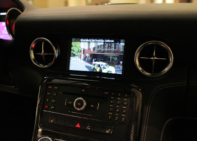
As you would expect, this top of the line Mercedes-Benz is loaded with all the bells and whistles. The vehicle’s integrated navigation system will be enhanced in certain regions by a fully functional JavaScript Maps API v3 implementation using Styled Maps, Google Places API, Places Autocomplete API, traffic layer, and the Panoramio layer as an Android App for the AMG Performance Media option. This provides the user with a familiar Google Maps interface in addition to the onboard maps from the navigation system.


(Mercedes-Benz SLS AMG Gullwing Coupe at the O’Reilly Where Conference - April 2012)

For night time driving the SLS AMG takes advantage of Styled Maps to create a map that’s easier to view in low-light situations and does not impede a driver’s night vision.


Chances are, if you’re driving this around all day, you’re going to get very hungry. That’s where the Places API integration with Places Autocomplete API comes in handy. Drivers can enter in what they’re looking for it, be it Thai food or pizza and the vehicle will return a list of nearby places along with address, distance, and rating.


Once the Places API has helped you decide what to eat and where you need to go, you can view the destination in Google Street View. In the image below, the system is displaying Street View imagery directly in front of the hotel in San Francisco where the vehicle was located for the 2012 O’Reilly Where Conference. From there you can enter directions that are displayed on a Google Map along with the option to display current traffic.


The engineers at Daimler have done an amazing job of taking Google Maps and combining it with one of the most-loved automobiles. There are many different types of developers in the Google Maps API ecosystem and great implementations like this remind us that the possibilities are almost endless!

Tuesday, April 3, 2012

Now see service alerts for the London Underground in Maps


Ahead of a busy summer in London, we are bringing real time service alerts for the London Underground to Google Maps. We’ll let you know of any disruptions on the Underground that are happening at the time you need them most. To see these alerts, click on a station in a timetable or in the public transport directions results.


Last summer we announced live transit updates, providing travelers with up-to-date information when planning their trips. We are excited about adding real time alerts for the 1 billion passengers that use the Underground every year.

In addition to the service alerts in real time, we’ve included planned engineering works for the weekends in our journey planner as well. When planning a trip for the coming weekend, we will show you the relevant subway alerts as part of the directions results. You can plan a trip for the weekend by changing the departure time in the ‘Get directions’ tab. Should there be planned engineering works for your route, you won’t run into any surprises on the day of travel.

As usual, this information is available on maps.google.co.uk for desktop and mobile, but also on Google Maps for Android. So even when you’re on the go, you’ll always be informed of the latest status of the Underground. Just tap on a station to see if there are any alerts active, or get directions to your destination to see if an alert affects your travels.


Public transport directions in Britain are available for all national train routes, London Underground, Overground, DLR and bus routes, and many local bus routes.

Whether you call London home or you’re one of the expected 31 million tourists visiting the city this year, we know that the addition of service alerts to Google Maps will make your travels across the city easier, faster and more convenient.

Monday, April 2, 2012

Get typical traffic for roads, not just highways


Have you ever been stuck in traffic during the heavy morning commute, or found yourself late for dinner plans because you left work right in the middle of the Friday night traffic? In addition to using Google Maps to find alternate routes and reach your destination faster, you may have also found the feature that shows typical traffic patterns on highways to be useful. Knowing the usual highway conditions during certain times of the day, like rush hour, can help you avoid traffic. And if you plan to avoid these highways, it’s also helpful to know the typical traffic patterns on the surrounding arterial roads as well.

Starting today, if you’re planning a trip for which you anticipate traffic, you can find out what typical traffic is like on these arterial roads, rather than just on highways. Simply type in your starting and ending points to get directions in Google Maps, enable the traffic layer on the upper right hand side of the viewport, and then click “change” in the legend to switch from live traffic to Typical Traffic for these roads.

Click traffic layer and then select day and time

You can now access this data for important arterials in cities around the world to help you get where you want to go, and on time! To illustrate the improved comprehensiveness of the traffic data now available, below are the before and after traffic screenshots for London:

London traffic for both highways and major roads

And of course, you can always help your fellow drivers and improve traffic data about road conditions and speeds by turning on the My Location feature on Google Maps for Android.

We wish you safe and happy driving!

Thursday, March 29, 2012

Traffic and Transit Come to Google Maps in Malaysia


We originally launched Google Maps in Malaysia back in 2009, and since then, Malaysians have been avid users of the service on both their desktops and mobile devices. So today, we are happy to announce three new features for Malaysia that we hope will make the map even more useful — especially for a nation with a lot of commuters.

First up, we have implemented the Traffic layer, which provides data about real time road congestion right on the map. Users can quickly see whether roads are congested or flowing freely based on colour coding — red for choc-a-bloc, yellow for slow moving, and green for smooth flowing.

Traffic Layer in Kuala Lumpur

Second, Transit information is now available, meaning that Malaysian public transportation details can now be found on Google Maps. This means that train and bus stops are now listed on the map, but more importantly, when you go to the “Get Directions” tab, you will see a new option — designated with a bus icon — to plan your route via public transport. The results of your search will give you step-by-step public transportation directions on how to get from Place A to Place B via bus, LRT, monorail, and Komuter train.
Transit Information in Google Maps Mobile in Kuala Lumpur

Finally, Google Maps is now available in Bahasa Malaysia, giving Malay native speakers better accessibility and the option of interfacing and navigating with Google Maps. Since 60 percent of Malaysians use Bahasa Malaysia as their primary language with over 90 percent proficiency, this localisation should make it easier for Malaysians to get the most from Maps.

To plan your journey and and get ahead in your travels, go to maps.google.com.my.

To learn more about traffic in Google Maps you can watch this video tutorial:


Find out your trip duration based on current traffic


Should I take public transit or a taxi to the airport? What’s the fastest way to get to my appointment on time: local streets or the expressway? Oftentimes, the answer to these questions depends on the current traffic conditions.

Now using both live and historic traffic data, Google Maps enables you to once again see the estimated length of time your journey might take. In areas where the information is available, this new and improved feature evaluates current traffic conditions and is constantly being refreshed to provide you with the most accurate, up-to-date estimate possible. To see this feature, simply access directions as you normally would on Google Maps. Below the time estimate for how long your trip might take without any traffic, you’ll see the adjusted estimate that factors in current traffic data.

For example, if I’m trying to get to JFK Airport from Manhattan I can see it is quicker to take the train versus a taxi during rush hour.

Comparing Driving Time vs. Transit Time

If the roads you’re traveling do not yet show the current traffic information, don’t despair. You can help your fellow drivers and improve traffic data about road conditions and speeds by turning on the My Location feature on Google Maps for Android.

We hope being able to plan your travels based on current traffic information saves you time, and perhaps even prevents some road frustration. Happy driving!

To learn more about directions and navigation on your Android phone, start here.

Monday, March 19, 2012

Get Traffic Conditions in Norway, New Zealand, and Hong Kong


We have expanded our live traffic coverage to Norway, New Zealand, and Hong Kong. Traffic in Google Maps was introduced in 2008, and since then our team has been working hard to bring this popular feature to more and more countries. Today, you can now get traffic conditions for major cities and highways in Norway, New Zealand, and Hong Kong.

Desktop View: Traffic conditions in Oslo, Norway

To do so, simply go to maps.google.com and click on the traffic layer in the widget you can find on the upper right hand side of the screen. This useful traffic information is also available on Google Maps for Mobile devices and Google Maps Navigation.


Mobile View: Traffic in Auckland, New Zealand and Hong Kong

If the roads you are traveling do not yet show traffic information, don’t despair. You can help your fellow drivers and improve traffic data by using Google Navigation or Google Maps for Mobile while traveling.

Wednesday, July 13, 2011

Live traffic information for 13 European countries


Since introducing the live traffic feature on Google Maps in 2008, our team has been working hard to make this feature available to more users in more countries. Just in time for summer travel, we’re delighted to announce that today we’re making traffic available in 13 countries in Europe. The new road traffic information is in the traffic layer on Google Maps and Google Maps for mobile, and Google Maps Navigation (Beta).

Left: Traffic layer Right: Getting routed around traffic in
Google Maps Navigation

Today we’re announcing new coverage in Austria, Belgium, Czech Republic, Denmark, Germany, Ireland, Israel, Luxembourg, Netherlands, Poland, Slovakia, Spain and Switzerland. Coverage includes all freeways and highways, as well as large roads in major cities. Users in the UK will also benefit from a finer grain of street level coverage.

Our Maps team in Zurich is especially excited about this release because many of us will now be able to personally benefit from the expansion of this traffic feature. For example, although I take public transit to work every day, I enjoy weekend drives to the Austrian Alps or the Italian lakes region, and having live traffic available on my phone helps me avoid the traffic at the Gotthard tunnel.

Traffic in Gotthard Tunnel, Switzerland

The live traffic layer is regularly updated to show information for traffic events from the last 5-10 minutes. Finally, you can learn more about typical traffic conditions for specific times and days of the week by clicking the “change” link in the traffic legend on Google Maps, and setting the day of week and time.

Tuesday, May 3, 2011

Traffic information coming to Google Maps in Sweden and Taiwan


When you turn to Google Maps to get from A to B, we want to help you find the quickest way to get there. Knowledge about the current traffic conditions on the roads can help you determine when to set out on your journeys and which routes to take.

With this in mind, we’ve just expanded our coverage of traffic information on Google Maps to include Sweden and Taiwan. Users in both places can now check the latest on road congestion with their desktop browsers or mobile phones. The traffic information covers all major thoroughfares as well as arterial roads in select cities.


Traffic information around Stockholm, Sweden

When accessing Google Maps, the widget in the upper-right allows you to select additional map layers that display more detailed information. To view traffic information, move your mouse over the widget and select the “Traffic” layer. The colors you see indicate the current traffic speed relative to the speed limit of the road. Red/black means stop start traffic, red is heavy congestion, yellow is a little slow, and green means you’re good to go. This traffic information is updated every few minutes.
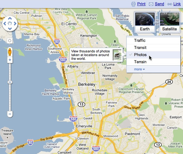
While on the go, you can see this same useful information by enabling the traffic layer on Google Maps for mobile, and help improve the traffic data as well. Here’s wishing everyone safe and swift travels!

Wednesday, January 19, 2011

See more views with the new Google Maps widget


When we launched Google Maps, we had one layer -- the map. Since then, we’ve added more than ten different ways to explore the world around you, including photos, transit and traffic information, as well as satellite and terrain views. We’ve now updated the design so that you can more easily see and switch between the various viewing options that are available.

Suppose you’re planning to meet your friend for a concert at the Greek Theater in Berkeley, and you want driving directions to plan your trip from your apartment in San Francisco. When accessing Google Maps, you’ll see a new widget in the upper right corner that allows you to easily select from either the Maps, satellite or Earth view. In addition, the single widget icon showcases all the different layers available to you, enabling you to quickly see more detailed information just by mousing over the ones you want.


Since it’s nearly rush hour and traffic information would be useful, you select that layer by clicking on it in the widget:


Unfortunately, the traffic layer shows that there are heavy delays along your route. You wonder if taking public transit is a better option, so you turn off the traffic layer by clicking on it again, and turn on the transit layer instead:


Ah, it looks like there’s a Bay Area Rapid Transit (BART) station near your apartment and one near the Greek Theatre. Public transit it is! If you also want to find a local spot to grab dinner after the show, you could search for [restaurants] in the same Google Maps window. Your recently viewed searches will appear in the new widget, enabling you to easily see both your destination and search results at the same time. This makes it easy to find a place nearby.


We hope this new all-inclusive widget for accessing map types, layers and recently viewed searches improves your experience exploring and navigating to the places you want to go!

Update (1/20): Sorry for the delay, but the new widget for viewing map types, layers and recent searches will be available soon. We'll update this post again when the widget is live.

Update (1/24): The widget is now live for all users on Google Maps. We hope you’ll enjoy exploring all the useful information available right on the map!

Posted by Amanda Leicht, Product Manager

Tuesday, August 25, 2009

Arterial traffic available on Google Maps


Commuters have long relied on traffic sites to help them determine their last-minute path around poor traffic on the highway. But if the traffic looks bad on the highways, you'll probably want to know how it looks on the alternate routes through arterials. I usually would just guess that the traffic on back roads is light, but with this new launch the guesswork is eliminated: Google Maps will now show you live traffic conditions on arterial roads in selected cities. Just zoom-in on the city you're interested in, and click the "Traffic" button in the upper-right corner of the map. As you zoom in closer to an area of interest, we'll color the arterial roads, in addition to the highways, to show current traffic conditions. Just as with the highways, the colors correspond to the speed of traffic (relative to the speed limit of the road): green is free sailing, yellow is medium congestion, red is heavy congestion, and red/black is stop-and-go traffic. For example, here's how traffic looks near the Google Seattle office today.

Here are some examples of what you can find out with this new feature:
Highways aren't looking great. Probably time to take the scenic route!

Trying to get to the airport on time? Now you can see the traffic on many of the roads leading there so you know the best route to take so you won't miss your flight:

If you have Google Maps for Mobile, you can see the same traffic there and, better yet, help improve the data: See our post on the Official Google Blog about traffic crowdsourcing. Here's to a happier commute!