Showing posts with label biking. Show all posts

Wednesday, September 5, 2012

Making exploration easier for people around the world with Google Maps


Maps keep our spirit of adventure alive by making it easier for us to explore the world around us. That’s why today, we’re making Google Maps even better with new turn-by-turn navigation with traffic conditions, biking directions, Map Maker and new Street View imagery in more locations globally. These improvements are part of our ongoing effort to build the best map we can -- one that’s comprehensive, accurate and easy for you to use.

First, we’re expanding Google Maps Navigation (Beta) with voice guided, turn-by-turn directions in thousands of towns across India. Navigation is one of the most frequently requested features in this region and can be especially helpful when driving in densely populated cities like Delhi or Bangalore. We’re also adding live traffic conditions for major roads with estimated travel times to help you save time and to reduce stress on the road.

Turn-by-turn voice navigation in New Delhi, India

Biking directions and Map Maker are also now rolling out to New Zealanders. Local cyclists can access biking directions directly on Google Maps, and use Map Maker to add bike lanes and trails if their favorite route is missing or they discover a new one. Beyond biking trails, Map Maker can also be used to make the New Zealand map more accurate with details such as new road names, building footprints and more.

Biking directions from Remuera in Auckland to the local Google office

Later today, we’ll also release new Street View imagery for more than 150 university campuses globally. With classes just getting started, freshman students, transfers and even empty-nesting parents can now familiarize themselves with college campuses around the world, including UCLA in the U.S., Pembroke College in the U.K., McGill University in Canada and Sophia University in Japan. These new panoramic views join our growing list of universities whose campuses are already available in Google Maps.


View Larger Map
Royce Hall at the University of California, Los Angeles

Finally, to celebrate all the places you can reach with Google Maps—all seven continents, the sky, the moon and even the depths of the ocean—we made a video that we hope will inspire you to keep exploring.


Keep exploring at maps.google.com/helloworld. Here’s to many new adventures.

Wednesday, August 29, 2012

Half a gigameter of biking navigation in 12 countries in Google Maps for Android


(Cross-posted on the Official Google Blog)

Whether you’re a seasoned century rider or a casual beach cruiser, finding the best biking routes can be a challenge. That’s why today we’re bringing mobile biking directions and navigation to the 10 countries where we launched desktop biking directions last month (Australia, Austria, Belgium, Denmark, Finland, the Netherlands, Norway, Sweden, Switzerland and the UK). Plus, we’re adding turn-by-turn, voice-guided biking navigation to Google Maps Navigation (beta) in every country with biking directions. Mount your device on your handlebars to see the turn-by-turn directions and navigation, or use speaker-mode to hear voice-guided directions.

Turn-by-turn biking navigation in Copenhagen


We know there are lots of ways to get from here to there, which is why in 2010 we added biking directions to Google Maps in the U.S. and Canada, and continue to work to bring more biking features to more places. Today, there are more than 330,000 miles (equal to more than 530,000 kilometers, or half a gigameter) of green biking lines in Google Maps. Dark green lines on the map show dedicated bike trails and paths with no motor vehicles, light green lines show streets with bike lanes and dashed green lines show other streets recommended for cycling. Biking navigation even helps you avoid steep hills.

Bike layer showing recommended streets for cycling in Stockholm


Where Map Maker and biking directions are both available, riders can add bike trails, lanes and suggested routes to Google Maps, helping to create a more comprehensive map for everyone living in or visiting their community. Thanks to the contributions of members of the biking community like Todd Scott and our partnership with nonprofits like Rails-to-Trails Conservancy, we’ve added bike data for hundreds of cities and trails to Google Maps in the past two-and-a-half years.

When you’re pedaling from Point A to Point B, we hope biking navigation will make Google Maps for Android more useful to you.


Posted by Larry Powelson, Software Engineer, Google Maps

Wednesday, August 22, 2012

Mapping the Motor City with Google Map Maker


Hailed as the birthplace of the automotive revolution, the city of Detroit, Mich. is taking its transportation legacy down new paths. As Detroit embraces a greener, non-motorized outlook, cycling is steadily increasing in popularity. The Michigan Trails and Greenways Alliance is facilitating this transition by creating an interconnected statewide system of trails and greenways, including the development of bike paths throughout the Detroit area.

As these new bike paths change the city’s landscape, Motor City residents need a more comprehensive map showing bike friendly routes. Todd Scott, the Detroit Greenways Coordinator, discovered that he could use Google Map Maker -- a free tool that allows anyone to make contributions to Google Maps -- to add new information on biking paths and trails in and around Detroit. Adding new bike paths not only makes the map more accurate, it also improves biking directions, making it even easier for people to find the quickest routes through town. Anyone can also enhance existing trails by including details such as the official name, surface type and bicycle suitability. Keeping Google Maps updated with the latest information means everyone in the community is able to find and enjoy these new additions to the trail system.

Learn more about Todd Scott and his mission to improve the map for cyclists in Detroit.

Building a more comprehensive, accurate and usable map for local cyclists is just one part of Todd’s mission. From the smallest town to a rapidly evolving city like Detroit, maps reflect the heart of a community. Whether you’re improving directions, adding local businesses or mapping an entire area from scratch, your local expertise will help make life easier for not only you, but all Google Maps users. As Todd says, “It goes beyond map making. It’s a way to take back your neighborhood.”

How are you mapping your world? Join the Map Maker Community and tell us your story.

Wednesday, July 11, 2012

Biking directions expands into Europe and Australia


Back in 2010 we added biking directions for users of Google Maps in the US and Canada. Helping cyclists navigate the bike trails throughout those countries proved hugely popular, so we’re wheelie excited to announce that starting today, we've also added extensive biking data to Google Maps for Austria, Australia, Belgium, Denmark, Finland, France, Germany, Liechtenstein, Luxembourg, Monaco, Netherlands, Norway, Sweden, Switzerland and the United Kingdom. In many of these countries we are also enabling biking directions in beta mode.

We know how popular cycling is in many parts of the world, so we wanted to include as much bike trail data as possible to provide efficient routes, allow riders to customize their trips, make use of bike lanes, calculate rider-friendly routes that avoid big hills and busy roads and to customize the look of the cycling map to encourage people to hop on their bikes. So that's exactly what we've done.

To start off, we've added information about bike trails, lanes and recommended roads directly to the map through the updated biking directions legend. This can help you get a better sense of your route, or easily find trails nearby for a recreational ride. When you're zoomed into a city, use the widget at the top right of the map to turn on the "Bicycling” layer.


Cycling is big in the Netherlands!

If you’re keen to start riding into work, or maybe just do your bit for the environment by swapping your car for a bike a couple of days a week, biking directions can help you find a convenient route that makes use of dedicated bike lanes and avoids hills whenever possible.

To use biking directions, select the cyclist icon from the list of routing modes when you search for directions. Watch this short video for more information. Biking directions are now available in Austria, Australia, Belgium, Denmark, Finland, Netherlands, Norway, Sweden, Switzerland and the United Kingdom.


A three hour ride through Swedish countryside

We’ve been working hard to add as much biking data to our maps as possible and we hope you enjoy this latest addition to Google Maps. That said, knowing the best roads for cycling is a challenge and there is only one group of people in the world who really know where the best cycle paths are in their regions: Cyclists!

Luckily, Google Map Maker is available in most countries where we’re releasing biking data and directions today, so we encourage all of you to help your fellow riders enjoy cycling as much as you do. Check out the brief tutorial and start adding those bike paths to your city or other places with which you’re familiar!


Add and edit bike data in Google Map Maker

If you live in a country that does not yet have Map Maker enabled, we appreciate your patience while we work to make it available as soon as possible. Or if you live in a place where biking directions are not yet enabled, but where you can already contribute to the map via Map Maker, we encourage you to add biking information in the meantime - and thanks for your help in making life easier for riders in as many countries as possible!

Tuesday, March 20, 2012

Start a love affair with Google Map Maker; now available in France and Monaco


Spring is in the air, carrying with it that special kind of love one feels when taking a romantic stroll along the Seine, visiting a countryside chateau, or finding an exotic garden by the sea. What better way to celebrate the season than by adding the places you love to Google Maps for the whole world to discover.


With Google Map Maker for France and Monaco, you can add your favorite places to the map. Start with your local bakeries, cinemas, parks, and museums. Once approved your contributions will appear on Google Maps, Google Earth and Google Maps for mobile for all the world to see. Now the French map can embody the rich culture and spirit unique to France, reflecting the heart of your neighborhood as you add details to the map.

Claude Monet’s house and studio, where he painted his water lilies, brought to life in Google Maps with Google Map Maker.

Parts of your neighborhood may already be mapped on Google Maps. If your favorite park is on the map, why not add the lake, football pitch and market to add that joie de vivre. Mark the best bicycle route through and edit road attributions so visitors can find their way around town. Join with other local mappers by bringing your local expertise to review their contributions to the map.

Google Map Maker proudly welcomes France to join citizen cartographers from across the globe as they create a more complete map of the world around us. To learn more, subscribe to the Map Maker YouTube Channel, and get started mapping. C’est génial!

Thursday, January 26, 2012

Google Earth 6.2: It’s a beautiful world


(Cross-posted on the Official Google and SketchUp blogs)

We're taking bird's eye view to a whole new level with the latest version of Google Earth, released today. With Google Earth 6.2, we’re bringing you the most beautiful Google Earth yet, with more seamless imagery and a new search interface. Additionally, we’ve introduced a feature that enables you to share an image from within Google Earth, so you can now simply and easily share your virtual adventures with family and friends on Google+.

A seamless globe


The Google Earth globe is made from a mosaic of satellite and aerial photographs taken on different dates and under different lighting and weather conditions. Because of this variance, views of the Earth from high altitude can sometimes appear patchy.

Today, we’re introducing a new way of rendering imagery that smoothes out this quilt of images. The end result is a beautiful new Earth-viewing experience that preserves the unique textures of the world’s most defining geographic landscapes—without the quilt effect. This change is being made on both mobile and desktop versions of Google Earth. While this change will appear on all versions of Google Earth, the 6.2 release provides the best viewing experience for this new data.

Grand Canyon before and after

Sri Lanka before and after

Share your explorations with Google+
Google Earth is a great way to virtually explore the globe, whether revisiting old haunts or checking out a future vacation spot. With the Google Earth 6.2 update, we’ve added the option to share a screenshot of your current view in Google Earth through Google+. If you’ve already upgraded to Google+, you can share images of the places you’ve virtually traveled to with your Circles, such as family, friends or your local hiking club. To try this new feature, simply sign in to your Google Account in the upper right hand corner of Google Earth and click “Share.” Images of mountains, oceans, deserts, 3D cities, your favorite pizza shop on Street View—you can now experience all these amazing places around the world with people on Google+.


Search improvements
We’ve also made some updates to the search feature in Google Earth. Aside from streamlining the visual design of the search panel, we’ve enabled the same Autocomplete feature that’s available on Google Maps. We’ve also introduced search layers, which will show all the relevant search results (not just the top ten), so now, when looking for gelato in Milano, you can see all the tasty possibilities. Finally, we’ve added biking, transit and walking directions, so if you’re itching for a change of scenery or looking for a new route for your regular commute, you can now use Google Earth to generate and visualize all your options.

Biking directions in Google Earth


Download Google Earth 6.2 and start exploring and sharing today!

New Biking Directions Legend


If you’re looking for new ways to get around for fun or to work, or might be trying to live a greener lifestyle in 2012, why not try biking? In March 2010 we introduced biking directions and since then Google Maps has been sharing biking directions with cyclists across the U.S and Canada.

Since no bike path is the same, many users have requested an easier way to differentiate the different types of bike routes that are available. Starting today, a new legend feature can help you understand what the different colors on the bike maps symbolize.
  • Dark green is for dedicated trails and paths
  • Light green is for roads with dedicated lanes
  • Dotted green is for roads that are friendly for cyclists
Look for the biking legend in the upper right hand corner of the map

You can view this legend by clicking on the widget in upper right corner of Google Maps and selecting the Bicycling layer. You can also access biking directions on your Android device or by going to maps.google.com on your mobile browser.

Whether you want to drive, take transit, walk or even bike, Google Maps can help you get around. To see how it works on your Android phone take a tour here.

Monday, December 5, 2011

Pedal to find your dream home with Google Maps


The features available in Google Maps are equally functional and fun. You can tour distant cities with Street View or map out a trip with multiple destinations using Custom Maps. Not only is Google Maps a great tool for everyday personal use, but it’s can also be used as a practical business tool. Such is the case for Matt Kolb, owner of Pedal to Properties.

Matt is an avid cyclist and a realtor based in Boulder, Colorado. In 2006, Matt decided to blend his hobby and career by founding his own real estate agency called Pedal to Properties. His company is built on the idea that by touring homes via bicycle, one can get a better sense of the local community and determine if a particular property is the right fit.


When Matt meets with clients, he locates various properties on Google Maps and creates a biking route of the houses they’ll visit that day, using Bicycling Directions as a guide. Home buyers are encouraged to interact with the map, using Street View to check out a property and its surrounding neighborhood, and using nearby search to take a look at local schools and businesses. Through this process Matt is able to narrow down viable homes for a specific buyer, making the experience enjoyable and time-efficient.

If you have interesting stories about how you use biking directions, Street View, or other Google Maps features to enhance your business, comment on our Google+ Page with #mygmapstory

Thursday, November 3, 2011

Share biking and walking directions with Custom Maps


Attention avid bikers and walking enthusiasts: You can now use your desktop to create a biking or walking itinerary using Custom Maps in Google Maps. You can choose to share these directions by allowing people to view your Custom Map and avoid the hassle of scribbling them down or printing them out. Additionally, you can access these stored directions from your phone with the Google Maps Android application.

This provides a quick and easy way to navigate trips that have multiple routes and stops when you’re on-the-go. Give it a try the next time you plan a group bike ride or to keep track of your favorite jogging routes.

To start, first get directions to your destination(s) and select the biking or walking icon in Google Maps. Next, scroll down to the bottom of the directions in the left-hand panel and click the “Save to My Maps” link.


You can then save the directions to an existing custom map or create a new one. Once the directions have been added to a custom map, you can continue to insert extra stops or make notes. After you complete mapping out your itinerary, you can choose to share it with friends or a workout buddy.


If you have an Android-powered device, you can access stored directions in Custom Maps right from your mobile phone - just click on the layers icon in the upper toolbar and select the saved Custom Map you want.

If you don’t have an Android phone, you can open your Custom Maps using your phone’s browser and visiting maps.google.com.


For more tips on custom maps, visit our help center.

Tuesday, October 11, 2011

Take the green route in Google Maps

(Cross posted from the Google Green Blog)

We’ve learned that most people who use Google Maps just want to get from Point A to Point B -- as quickly and painlessly as possible. Whether it’s planning a weekend bike route, finding the quickest roads during rush hour, or identifying bus paths with the fewest transfers, people are making the most out of Maps features to travel faster and greener. Here’s how you can use Google Maps to minimize your impact on the environment.

Commuting by bike
As an avid cyclist, I feel very fortunate to live in Boulder, Colorado and be surrounded by over 300 miles of bike lanes, routes and paths. When the weather is cooperating, I try to commute to work every day. It’s a great way to stay healthy and arrive at the office feeling awake! According to Biking Directions in Google Maps, it takes me 10 minutes to travel 2 miles from Point A (my house) to Point B (the office). It also shows three alternative routes, and I can check the weather in Google Maps to see if I’ll need a rain jacket for the ride home. I can also use Biking Directions on my mobile phone, which came in handy for me during a biking trip in Austin when I got lost on a major highway and needed a safe route back to the hotel.

Did you know that Google Maps has biking directions available in over 200 US cities and in 9 Canadian regions? A collaboration with Rails to Trails, an organization that converts old railroad tracks into bike paths, has made information about over 12,000 miles of bike paths available to Google Maps users.

Taking public transit
Millions of people use Google Transit every week, viewing public transit routes on both Google Maps and Google Maps for mobile in over 470 cities around the world. You can take a train from Kyoto to Osaka or find your way around London on the Tube. In some places, you can compare the cost of taking public transit and driving by viewing the calculation below the list of directions (like in this example). Feel free to customize your routes and departure and arrival times under “Show options” to minimize walking or limit the number of transfers. You’ll know if your bus is late by checking out live transit updates.

Being green in the car
According to the 2011 Urban Mobility Report by Texas Transportation Institute at Texas A&M University, motorists wasted 1.9 billion gallons of fuel last year in the US because of traffic congestion, costing the average commuter an additional $713 in commuting costs. You can save time and money by clicking on the Traffic layer in the top right corner to view real-time traffic conditions on your route, and then drag and adjust your route to green. If you need directions in advance, save paper by sending your directions directly to your car, GPS, or phone. The Send-to-Car feature is available to more than 20 car brands worldwide, and the Send-to-GPS feature is available to more than 10 GPS brands. And for those of you who drive electric vehicles, you can search for electric vehicle charging stations by typing “ev charging station in [your city]” and recharge.

As you can see, Google Maps is loaded with features to help you save time, save money, and get where you need to be -- all while minimizing your commute’s impact on the environment. Go green with Google Maps, and safe travels!

Wednesday, December 1, 2010

Gearing up: Biking directions added to Google Maps for Canada


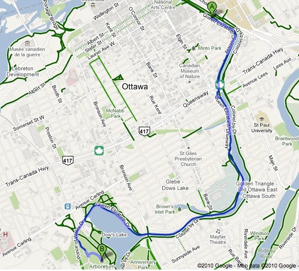
Earlier this year, we added biking directions to Google Maps for the United States, enabling users to more easily find their way when they’d like to take a two-wheeled alternative to walking, driving or public transit. Today we’re expanding biking directions to select regions in Canada: Ottawa, Toronto, Edmonton, Kelowna, Vancouver, Calgary, Winnipeg, Gatineau and Waterloo.

Biking directions on Google Maps enables you to hop on your bike and get from point A to point B, whether you’re planning your daily commute, plotting out your weekend ride, or taking a lunch break. These biking directions easily integrate with all the other Google Maps features, so you can do a local business search to find a great new cafe, read reviews to help you decide if it’s right for you, get biking directions over to it, and pull up Street View to preview your route.


We’ve factored in variables such as hills and bike lanes, and have color-coded roads based on their biking suitability. Dark green indicates a dedicated bike-only trail; lighter green indicates a dedicated bike lane along a road; and the dotted green line indicates roads that do not have bike lanes but tend to be suitable for biking. Just like with driving directions, you can drag the route to customize your trip.


We’ve partnered with a number of Canadian cities, as well as the National Capital Commission, to provide this useful information to cyclists. Ottowa Mayor Larry O’Brien also shared his perspective at the recent Sustainable Mobility Summit.
“The City of Ottawa has always placed a high importance on encouraging residents to use sustainable transportation alternatives like cycling. By having the City's paths, bike lanes and suggested routes available on Google Maps we are providing a convenient, accessible technology for our residents to plan their cycling trips to where they work, live and play.”
City planning agencies can learn more about opportunities to add their data to Google Maps by visiting to maps.google.com/content.

To get started finding biking directions in Canada, visit maps.google.ca/biking. We encourage all riders to help make our biking directions more complete by reporting any missing route information or problems via the “Report a Problem” tool.

Posted by Shannon Guymon, Product Manager

Wednesday, August 18, 2010

A Big Thank You to our Growing Community of Bike Map Contributors


When we added U.S. biking directions to Google Maps back in March, we were eager to see the response from the cycling community. Through our partnership with the Rails-to-Trails Conservancy, we had detailed bike lane and trail information for 150 cities; and for the rest of the country, we recommended routes based on other data such as the size of the road, speed of traffic and hill steepness. On one hand, it would’ve been ideal for our directions feature to know about all the bike lanes and trails in the country. But on the other hand, we were aware that biking directions were one of our most-requested features and we wanted to provide information for bicycling fans as soon as possible.

So rather than wait, we decided to launch biking directions in “beta” and ask our community of bicycle-bound users for their help improving our bike maps. Through our “Report a problem” tool, any user can send us corrections or recommend improvements, and receive notifications from Google when their report has been resolved. We always knew the cycling community would be a passionate bunch, but the response to both our biking directions feature and our call to join in the effort to improve our bike maps has surpassed our happiest expectations.

More than 10,000 people have submitted about 25,000 suggestions for improvements to our bike maps. With their help, we’ve added bike lane and trail data for an additional 80 cities since our initial launch. This is an exciting and humbling response from the Google Maps community. It’s like having 10,000 new members of our bike maps team, contributing their time and energy to make Google Maps more useful for everyone.

These contributors have impacted biking directions across the nation - in small and large ways. Here are some examples of suggestions we’ve received:

  • One user simply pointed out to us, “Wall Township Bike path - http://www.wallrec.com/bicycling.htm.” Our response to that short and sweet message? Here it is:


  • Some else sent a note saying, “CSUS - there has been a bike/foot traffic tunnel that connects elvas ave to College town dr for about 6 years. it is located between 64 & 65 st.” Well, that’s handy to know! Done:


  • And yet another user shared, “Cycle/hiking path continues to the East across Switzer and connects with the path that is currently shown on google maps ~2.5 miles to the ENE at 130th and Metcalf Ave. Details on Overland Park website http://www.opkansas.org/Resource_/PageResource/Maps-And-Stats/Maps/Adobe-Acrobat-PDF-Maps/bike_route_plan.pdf Thanks.” Awesome! Overland Park is now looking pretty good for cyclists:


This is how we’ll build a great cycling map: Bit by bit, getting better with every tip and suggestion that users share about the lanes and trails they’ve ridden.

We want to say “Thank you!” to all those who’ve answered our call for bike map contributions. Clearly our users are passionate about helping to make our maps better, so we’re working hard to make the improvement process even easier and to speed up the processing time for user contributions.

In the meantime, happy biking! Just remember that our biking directions are still in beta, and to always use your judgement - don’t ride down any road that makes you uncomfortable. And if we’ve recommended a road that shouldn’t be used by the average bicyclist, let us know!

Wednesday, May 12, 2010

What’s new with biking directions on Google Maps?


Since 1956, May has been recognized as National Bike Month and in most cities, Bike to Work Day falls during the week of May 17-21 (but for those of us in San Francisco, Bike to Work Day is coming up tomorrow on May 13). To help celebrate all these festivities and help make it easier for folks around the country to participate, we’ve been busy improving biking directions on Google Maps. Here’s what’s new:

Biking directions for mobile
Check out yesterday’s post for some great news: biking directions are now available on mobile! Back when we first launched in March, we promised we were working hard on it, and now the wait is over for Android users. Now you can plan out your route to work directly from your phone - and if end up having such a great time while you’re on your way, pull out your phone and search for some new rides!

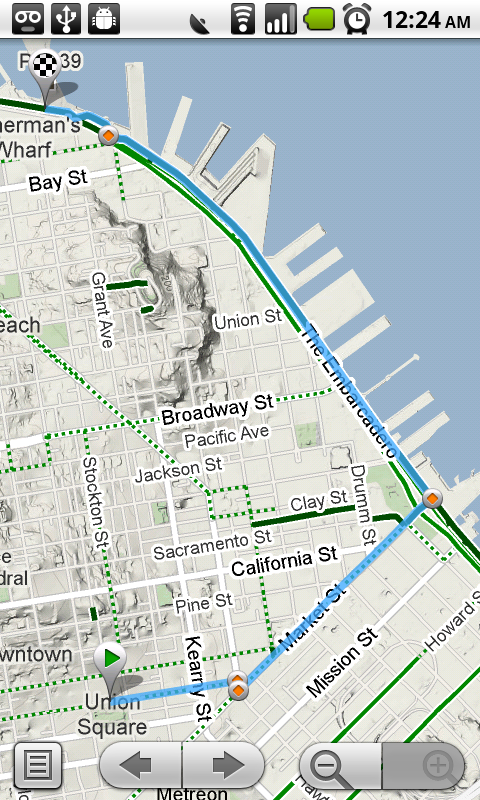
In addition to getting customized routes, you can also turn on the Bicycling layer to see dedicated bike-only trails (dark green), roads with bike lanes (light green), or roads that are good for biking but lack a dedicated lane (dashed green).


Biking Layer in the Google Maps API
There are two important parts of Google Maps biking directions: the bike specific routing and the customized look and feel of the bicycling layer. Our routing algorithm tries to put riders on trails and roads with bike lanes or recommended streets as much as possible, while the bicycling layer visually highlights the information that's most relevant to cyclists. We've drawn attention to the bike trails, bike lanes, and bike-friendly roads with color-coded lines on the map. This custom layer is now available in the Maps API v3, so when you add biking directions to your website, users will get the same visually rich experience that they get on Google Maps. Globe Bikes is already taking advantage of this improvement by placing our simple biking directions gadget on their website. If you have the skills to copy and paste, you have the skills to add the gadget to your website.


Ongoing Data Quality improvements
In March we launched biking directions with more than 12,000 miles of trails and bike lane data for 150 cities across the country. We’re continually working to improve this coverage by adding new trails and route information submitted by our users via the “Report a Problem” tool. So far we’ve received thousands of suggestions and tips from dedicated cyclists around the country and have made a number of additions and improvements. You’ll now find 39 more cities with trail and bike lane data; for example, check out all the new data in Sacramento.

Hopefully this has managed to convince you to hop on your bike to get to work - and lots of other places - this month. Before you head out, you can check out the League of American Bicyclists' website for more information about special Bike Month festivities in your part of the country, as well as tips for a safe and fun ride.

Tuesday, May 11, 2010

Google Maps for Android Gets Biking Directions, Navigation Shortcut, Sharing, and More

[Cross-posted from the Google Mobile Blog]

Starting today, Google Maps for mobile has a few new ways to help you and your friends quickly get to where you’re going whether you’re on 4 wheels or 2 (or maybe even 3). With Google Maps 4.2 for Android you can now get biking directions on the go, start Navigation from your Home screen, share places with friends, and more.

Biking directions
Since launching biking directions on desktop Google Maps, we’ve wanted to get you biking directions, lanes, and trails on your phone too. Just in time for National Bike Month, select the bike icon when getting directions to get an optimal bicycling route in the U.S. If you’re in the mood for a more scenic ride, you’ll also see the Bicycling layer on the map which shows dedicated bike-only trails (dark green), roads with bike lanes (light green), or roads that are good for biking but lack a dedicated lane (dashed green). You can always turn on this layer from the Layers menu to pick your own route. Add in the Labs’ Terrain layer, and you can decide to either climb or avoid that big hill on the way home!


Google Navigation shortcut
If you’re driving instead of riding, we wanted to make it easier and faster for you to get on the road with Google Maps Navigation as soon as you’re ready. With the new Navigation shortcut, you can pick a destination and be on your way with as little as 2 taps of your finger. Select the “Navigation” icon in your phone’s app launcher to get the new destination selection view. Then, speak or type your destination, pick one from your contacts, choose a starred place, or select a recent destination. Navigation will begin and you’re good to go. Make it even easier on yourself by adding the Navigation icon right on your Home screen.


Sharing
Once you figure out where you’re going, why not get some friends to meet you there? From any search results page, choose to “Share this place” to send that place’s info, such as its address and phone number, to whomever you like. If you want to meet someone on a street corner or gather friends at an outdoor concert, you can also send an exact location from the map -- even a snapshot of your current location. Just use the share option after selecting a point on the map, your “My Location” blue dot, or yourself in Latitude if it’s enabled. Whether you’re sharing a place or a location, you’ll be able to send it to small groups via an email or text message or send it widely with apps like Google Buzz, Facebook, or Twitter.

Get these new features by searching for Google Maps in Android Market from Android 1.6+ phones (On your phone now? Tap here). Update Maps to version 4.2, available in all the countries and languages where Maps is currently available. Visit our Help Center to learn more, ask questions in our Help Forum, or give us suggestions and vote on other people’s on the Mobile Product Ideas page.

Wednesday, March 10, 2010

It's time to bike


Over on the Official Google Blog, you can read a very, very exciting announcement: Google Maps now offers biking directions! As my teammate Shannon mentions in that post, we've been constantly asked when this feature will be made available. But as an engineer working on the directions team, I'd often get questions about why Google Maps didn't already have biking directions. After all, we've had driving, walking, and public transit directions for some time, so what is it about biking directions in particular that presents an engineering challenge?

Well now that the good news is out, I can lift the curtain and explain the many factors and variables that we've had to take into account to put this whole feature together:
  • Bike trails: Our maps contain over twelve thousand of miles of biking trails. First, we had to figure out where trails are, so we worked with the Rails-to-Trails Conservancy to get much of our trail data. Once we had trails mapped out, the next task was to incorporate them into our routing algorithm. The algorithm is weighted to strongly prefer routing on these trails rather than roads open to automobile traffic, so your directions will try to put you onto a trail as long as it won't take you totally out of your way. On our bicycling layer (found under the 'More' button), these trails show up in dark green.
  • Bike lanes: For more than 150 cities in the US, we know which streets have dedicated bicycle lanes. These are also prioritized when coming up with a routing suggestion. On the bicycling layer, you’ll see these roads indicated in bright green.
  • Recommended routes: For many cities we also provide information on streets that have been designated as good for cyclists, so we them into account in our algorithm. These roads are indicated with dashed green lines on our bicycling layer.
  • Uphill slopes: l don't know anyone who enjoys biking up a hill, especially when you're trying to get somewhere you need to be. Going uphill is worse than simply being much slower; it's also exhausting and can take a toll on the rest of your ride. Our biking directions are based on a physical model of the amount of power your body has to exert given the slope of the road you’re biking on. Assuming typical values for mass and for wind resistance, we compute the effort you’ll require and the speed you’ll achieve while going uphill. We take this speed into account when determining the time estimate for your journey, and we also try hard to avoid routes that will require an unreasonable degree of exertion. Sometimes the model will determine that it's far more efficient to make you ride several extra blocks than to have to deal with a massive hill. My teammates in San Francisco were relieved to see that this does indeed work!
  • Downhill slopes: Many cyclists will tell you that going downhill is annoying for a different reason: you may have to ride your brakes all the way down. All else equal, we try to avoid routes that require a lot of braking. Of course, in some cities, including my hometown of Seattle, this isn’t always possible! And if you feel like you need a big workout and want to climb some hills, or if you just love that wind-in-your-hair feeling of a long downhill (you better be wearing a helmet and staying safe!), you can always turn on the terrain layer to check out the hilliness of an area for yourself.
  • Busy roads: Cyclists often tend to prefer to stay off of fast roads, and not even cross them unless it's necessary. This is roughly the inverse of driving directions, where you want to stay on arterials and freeways, so we had to rework a lot of those fundamental calculations when coming up with our biking directions algorithm.
  • Busy intersections: We try to avoid making you cross busy streets with a lot of car traffic and long wait times.
Even having figured out how to account for all these variables and cost-estimates in our algorithm, the biking direction feature would not have been possible without our new base map data which allowed us the flexibility to easily incorporate bike trail data, a fundamental part of this feature. It also allowed us to readily incorporate feedback directly from our users, and we welcome all your feedback and suggestions via the "Report a problem" tool -- after all, biking directions are still in beta and we're continuing to work on adding more data about bike trails, bike lanes, and preferred roads. Both of these updates were made in October, at which time we promised that that biking directions were in the works, and now five months later: here they are!