Showing posts with label googlenew. Show all posts

Wednesday, December 5, 2012

Building a better map of Europe


More than a billion people use Google Maps each month to find their way around town and around the world.  To help these people get exactly the information they need, the Google Maps team works constantly to ensure that the geographic data behind our maps is comprehensive and accurate. As part of this ongoing effort, we’ve just released updated maps for 10 countries and regions in Europe: Andorra, Bulgaria, Estonia, Gibraltar, Hungary, Latvia, Lithuania, Slovakia, Slovenia and Spain.

Today’s update is part of a project called Ground Truth that began in 2008. Through this initiative, we acquire high-quality map data from authoritative sources around the world and then apply a mix of advanced algorithms, supplemental data (including satellite, aerial and Street View imagery), and human input to create a map that corresponds as closely as possible to the real-world facts that you’d find if you were to visit that location.

For example, this update adds a new 70-km section of Bulgaria’s Trakiya motorway, which opened recently to drivers but hasn’t been reflected on most maps of the region until now.


Explore this area on Google Maps

But roads and highways alone don’t define the character of a place, and they aren’t always sufficient to help you get around. So Google Maps also integrates information such as walking paths, ferry lines, building outlines, park boundaries, university campuses and more—providing a richer, more comprehensive and more realistic experience for locals, visitors and armchair travelers alike.

Our new map of Spain, for example, not only shows the famous Museo del Prado and Parque del Retiro in Madrid, but also includes additional building models in surrounding neighborhoods, the well-known “Estanque” (or pond) in the center of the park, and detailed walking paths throughout both the park and the nearby Royal Botanical Gardens.


Explore this area on Google Maps

Of course, the world is always changing, and we want Google Maps to change with it. So when you notice something on the map that needs updating, let us know through the simple “Report a problem” tool in the lower right corner of the map. We’ll make the appropriate changes to the map—often within just a few minutes or hours of reviewing and verifying your feedback! This tool launches today in the 10 places where we’ve updated our maps, and is already available in dozens of other countries around the world.

With today’s release, the maps that we’ve built through our Ground Truth initiative are now available in a total of 40 countries worldwide. To see the progress we’ve made to date, take a look at the image below.


We hope today’s launch of more comprehensive and accurate maps of Europe will help you explore amazing places from Barcelona and Budapest to Bratislava and beyond.

Posted by Brian McClendon, VP Google Maps and Google Earth

Wednesday, December 14, 2011

Mapping made easier with the new Google Map Maker


With 2012 approaching, we're getting a head start on our New Year's resolution to shed some excess weight and improve our overall appearance. You may have seen our ongoing efforts to improve the look, feel, and user experience across many other Google products to date. And with Google Map Maker available in the United States, Canada, and more than 180 other regions, it's time for another makeover. Today, we’re revealing a new version of Google Map Maker to help users map the places they know best and make their hometowns sparkle on Google Maps.


Start with a walkthrough of the new Google Map Maker

With Map Maker, you can easily help ensure that the changing world around you is accurately reflected on the map. Add your favorite gift shop, the nearest tree farm, or even the golf course where you once got that hole in one. It’s also easier to mark the best route to Grandma’s house and draw better buildings with courtyards and crisper corners. The options are endless when it comes to mapping the places you know and love. Once approved, your contributions will appear on Google Maps, Google Earth and Google Maps for mobile for all the world to see.


You don’t have to be an expert to start using Google Map Maker. High school student and Eagle Scout Tommy Bruce is a mapping superstar who finds mapping fun, fulfilling, and a simple way to help those in his community have the best, most comprehensive information possible. He started by mapping bike trails in his hometown of Mooresville, North Carolina and is now on an exchange program in Puebla, Mexico, mapping unmarked rivers that run through town! After witnessing Tommy’s accomplishments firsthand at the U.S. Geo User Summit, even his mother Margaret began thinking of places that she’s eager to put on the map. Why not make your New Year’s resolution to improve the map for millions of people? Start here.

Posted by Kaushik Sridharan, Software Engineer

Thursday, September 29, 2011

Refocused Design Evolution, Continued

In June we launched the start of a comprehensive visual redesign for Google Maps founded on three key principles: focus, elasticity, and effortlessness. This week we’re continuing to implement that philosophy by improving and evolving a few key features.
Our new pin

Perhaps the most notable change is an update to the styling and color of our iconic pins across all Google properties. This change reflects our interface’s recent design evolution, introducing a more harmonious visual relationship between the on-map markers and the map itself.


Our on-map controls are also now more visually aligned with the rest of our design system. Together these changes reflect our recent efforts to reduce unnecessary clutter and give greater priority to information on the map.


In the header we’re also introducing more prominent buttons for Directions and My places integrated into an elastic interface that expands and contracts to best fit your browser window size.

Putting all of these changes together you get:


We hope you find this a welcome update making Google Maps more functional, effortless, and enjoyable. This is just one part of the many design updates that will continue rolling out across Google Maps in the coming weeks and months, so keep an eye out for more!

Wednesday, September 14, 2011

+Snippets on Google Maps: if you can see it, you can share it


[Cross-posted from the Official Google Blog]

We recently launched +snippets for users and publishers, making it easy to visit a webpage and then share it on Google+. We want to make sharing across Google just as easy, so today we're bringing +snippets to Google Maps.

Suppose you’re planning a weekend trip to Napa. Your packing list probably includes driving directions, hotel information and a list of nearby wineries. Many of you visit Google Maps for this kind of information already. But with +snippets, Google+ users can easily share directions or places (for example) with fellow travelers. Just click “Share...” in the Google+ bar at the top of the screen, and whatever you see on Maps is what you’ll see in the sharebox—ready to share with your circles:


+Snippets on Google Maps: Directions, Places, search results

With today’s launch, Google Maps joins other Google products like Books, Offers and Product Search in having +snippets. And like Maps, what you see onscreen is what you share—just click on “Share...” in the Google+ bar to reveal the +snippet:


+Snippets on Google Books, Offers and Product Search

We’ll be rolling out +snippets to many more Google products in the future, so stay tuned. In the meantime, we can’t wait to see how other publishers customize their own +snippets, all across the web.

Thursday, August 25, 2011

Search Google Maps out loud


Tired of typing? Without using your keyboard, you can now talk into Google Maps to look for places and get directions. If you’re using a Chrome web browser in the U.S. (English only for now), simply click the microphone icon and speak into your computer.


Click the mic and ask for a place to get started


Using voice search can make it easier to find hard-to-spell places (like Poughkeepsie or Liechtenstein) or simply get directions without typing (for example, say “Directions from Los Angeles to San Francisco”). Or if you’re interested in exploring the world through the Earth layer (using the plugin), you can just say where you want to go and fly over to that location directly within your browser!


Fly to places just by saying your query


If you didn’t already know, you can also use voice commands on Google.com, your Android device or on the Google app for your iPhone. Take a look at this video for desktop voice search to find out how voice actions can make your life easier.


Have fun talking out your searches on Maps!


Thursday, August 18, 2011

Rain or shine, see the weather in Google Maps


Whether you’re organizing a trip overseas or a picnic at a local park, knowing the weather forecast is a crucial part of the planning process. Today, we’re adding a weather layer on Google Maps that displays current temps and conditions around the globe, and will hopefully make travel and activity planning easier.


To add the weather layer, hover over the widget in the upper right corner of Google Maps and select the weather layer from the list of options. When zoomed out, you’ll see a map with current weather conditions from weather.com for various locations, with icons to denote sun, clouds, rain and so on. You can also see cloud coverage, thanks to our partners at the U.S. Naval Research Lab. And, if you look closely, you can also tell if it’s day or night around the world by sun and moon icons.


Enabling the weather layer also gives you an instant weather report for friends and family living around the world. For example, it looks like my family in London isn’t experiencing the best summer weather right now:


Weather near London, UK


Clicking on the weather icon for a particular city will open an info window with detailed data like current humidity and wind conditions, as well as a forecast for the next four days. Below is the upcoming forecast for my location in wintertime Sydney, which seems to have the similar weather as London!


Weather near Sydney, Australia in satellite view


Changing the units of wind speed (Mph/KMph) and temperature (F/C), and enabling or disabling the clouds (when you’re zoomed out), can also be done from the left-hand panel.


Weather left hand panel


Get started now and check out the weather layer here.


Update 8/18/11 at 3:30pm: We've updated the post to clarify that while the cloud data for this layer comes from U.S. Naval Research Lab, the weather data is from our partner weather.com.


Wednesday, April 20, 2011

Bringing Google’s Cloud technology to Google Earth & Maps Enterprise


Our vision for Google Earth and Google Maps has always been to create a digital mirror of the world where any user, anywhere, and from any device or platform can access current, authoritative, accurate, and rich information about the world around them. In order to provide fast and timely maps to our users, we’ve developed powerful geo infrastructure that lets us process and serve petabytes of imagery and basemap data to hundreds of millions of users.

We frequently hear requests from governments and businesses - some of whom use our existing Enterprise Earth & Maps products today - that they would like to have greater access to some of the infrastructure we’ve built in order to more easily store their geospatial data in the cloud and more easily build and publish maps for their users.

Today we announced Google Earth Builder, which continues the spirit of providing more access to Google’s core infrastructure, such as Google App Engine and Google Exacycle.


Google Earth Builder is an Enterprise mapping platform powered by Google’s cloud technology. We’ve built Google Earth Builder with the idea that any organization with their own mapping data - be it terabytes of imagery or just a few basemap layers - should be able to upload and manage that data in the cloud. They can use Google’s scalable infrastructure to process and securely serve it through familiar Google Earth and Maps interfaces to their users.

Our goal for Google Earth Builder is to enable Enterprises that work with geospatial data and create online maps to be able perform these tasks in the cloud. Over time we anticipate providing access to more and more of our geo infrastructure through Google Earth Builder, so businesses have more options for how to process, publish and analyze their geospatial data. We’re excited to launch Google Earth Builder in Q3, and in the meantime if you are interested in learning more then please get in touch.
Tuesday, February 1, 2011

Street View takes you inside museums around the world


We’re always excited to share new Street View imagery with users, whether a botanical garden in South Africa or ski slopes in Canada. While Street View has enabled users to visit places all around the world virtually, the demand to show a broader range of popular locations has been great. Today we’re entering new territory with our experiment to take Street View technology indoors.

The Art Project, developed by a group of art-loving Googlers, is a collaboration between Google and 17 of the world’s most acclaimed museums. Select works of art chosen by these partners are now available for you to explore through Street View in Google Maps, and the Art Project site offers an immersive experience to explore museum information, floor plans, more than 1000 high-resolution pieces, and Street View imagery. Learn more about the Art Project on the Official Google Blog.

To take you inside magnificent spaces like the State Hermitage Museum in St. Petersburg, Russia, our team needed to update the way we go about gathering Street View images.

The State Hermitage Museum, St. Petersburg, Russia

Street View imagery is typically collected using cars and we’re able to utilize the ample roof space and interior storage of these vehicles for all of our equipment. To take Street View technology indoors, we needed to fit all of the equipment on a much smaller vehicle, a push-cart lovingly dubbed Trolley.

Pictured with Trolley: Daniel Ratner, Mechanical Engineer and Matt Williams, Program Manager at the Van Gogh Museum in Amsterdam, The Netherlands

Trolley is outfitted with a few components that are key to collecting indoor imagery: a panoramic camera to collect 360-degree views, lasers to capture distances to walls, motion sensors to track Trolley’s position, a hard drive to store data, and a laptop to operate the system.

With this adapted equipment, we were able to gather the imagery and bring it into Google Maps, and you can now drag Pegman directly onto museums like the Metropolitan Museum of Art in New York City to explore their impressive European Paintings wing.

The Metropolitan Museum of Art, New York, United States

You can also enter museums when you’re already looking at Street View imagery of the museum exterior. You’ll notice new double-arrow navigation links from the nearby streets leading you inside, as you can see here for the Palace of Versailles.

Palace of Versailles, Versailles, France

Once inside the museum, you can navigate around rooms freely with the navigation arrows or simply click on a distant spot to jump to a closer view. Movement between floors can also be done with ease by selecting a different level from the new control panel below the Street View compass and zoom controls.

Alte Nationalgalerie, Berlin, Germany

We’re excited to introduce this new imagery in Street View, and will continue to improve and develop this indoor experience. To explore these museums directly through Street View in Google Maps, visit maps.google.com/museums, and to view high-resolution artwork and learn more about the museums, check out the Art Project at www.googleartproject.com.

Posted by Jonathan Siegel, Software Engineer

Thursday, January 27, 2011

Sign up for imagery update alert


Users in the Google Earth forum often ask about the age of satellite imagery and when the content will be updated. While we aren’t able to tell you in advance when our imagery will be updated, we can now notify you after new images are added to an area that you’re interested in.

With our Follow Your World application, you can register points on the globe and we’ll send you an email update whenever the imagery is updated there.


In just three easy steps, you can add points such as your hometown, your college football stadium, or just about any place on Earth. And since Google Earth and Google Maps share the same imagery, this tool is equally handy for enthusiasts of both products. Follow Your World also provides a handy dashboard to manage your subscriptions.

Whether you’re an armchair geospatial enthusiast, or you frequently use aerial imagery from Google Earth or Google Maps in your work, we invite you to give this new app a try so you’ll be the first to know.

Posted by Jeral Poskey, Google Earth support team

Wednesday, January 19, 2011

See more views with the new Google Maps widget


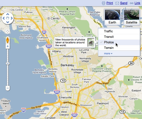
When we launched Google Maps, we had one layer -- the map. Since then, we’ve added more than ten different ways to explore the world around you, including photos, transit and traffic information, as well as satellite and terrain views. We’ve now updated the design so that you can more easily see and switch between the various viewing options that are available.

Suppose you’re planning to meet your friend for a concert at the Greek Theater in Berkeley, and you want driving directions to plan your trip from your apartment in San Francisco. When accessing Google Maps, you’ll see a new widget in the upper right corner that allows you to easily select from either the Maps, satellite or Earth view. In addition, the single widget icon showcases all the different layers available to you, enabling you to quickly see more detailed information just by mousing over the ones you want.


Since it’s nearly rush hour and traffic information would be useful, you select that layer by clicking on it in the widget:


Unfortunately, the traffic layer shows that there are heavy delays along your route. You wonder if taking public transit is a better option, so you turn off the traffic layer by clicking on it again, and turn on the transit layer instead:


Ah, it looks like there’s a Bay Area Rapid Transit (BART) station near your apartment and one near the Greek Theatre. Public transit it is! If you also want to find a local spot to grab dinner after the show, you could search for [restaurants] in the same Google Maps window. Your recently viewed searches will appear in the new widget, enabling you to easily see both your destination and search results at the same time. This makes it easy to find a place nearby.

We hope this new all-inclusive widget for accessing map types, layers and recently viewed searches improves your experience exploring and navigating to the places you want to go!

Update (1/20): Sorry for the delay, but the new widget for viewing map types, layers and recent searches will be available soon. We'll update this post again when the widget is live.

Update (1/24): The widget is now live for all users on Google Maps. We hope you’ll enjoy exploring all the useful information available right on the map!

Posted by Amanda Leicht, Product Manager

Thursday, December 16, 2010

The next generation of mobile maps

[Cross-posted from the Official Google Blog and Google Mobile Blog]

I’m excited to announce Google Maps 5.0 for Android, with two significant new features: 3D interaction and offline reliability.

We launched Google Maps for mobile a little more than five years ago. Since then, we’ve added dozens of features, and we’ve grown from a few thousand to more than 100 million users. Still, a couple of things have remained the same: a flat, north-up map and the need for a strong Internet connection. Today, we’re changing that for the first time.

Tilt while zoomed in (left) or use compass mode (right) to orient yourself with 3D buildings.

Explore maps in 3D
Until now, Google Maps has always downloaded the map as a set of small, square images that we stitch together to form the map you see. (You’ve probably seen those gray squares getting filled in, block-by-block, as the images load over the network.) Starting today, we’ll use vector graphics to dynamically draw the map on your device as you use it, allowing you to interact with it in new ways:
  • Tilting: Drag down with two fingers to tilt the map. Tilt while zoomed in on one of the 100+ cities around the world with 3D buildings to see a skyline spring to life.
  • Rotating: Twist with two fingers to rotate the map. After tilting to see 3D buildings, rotate around them to gain a new perspective from any direction.
  • Smooth zooming: Slide two fingers together or apart, and see the map and labels continuously scale to any zoom level, stopping when your fingers stop.
  • Compass mode: Center the map on your location, and then tap the compass button in the top right corner. The map will flip into 3D mode and start rotating to match your perspective, while still keeping all the labels upright and readable.
I found 3D buildings especially useful on a recent trip to New York. From my hotel to the Google office in Chelsea and bars on the Lower East Side, this richer representation of the real world made the map much more helpful. And whenever I walked out of a building or subway station, I used compass mode to get myself quickly oriented and on my way. Check out the video below to see tilt, rotation, zoom and compass mode in action, or see more pictures.


Offline reliability
Google Maps has always been, and continues to be, a fundamentally Internet-connected experience, meaning you always get the freshest map and place data, search and voice search, live traffic conditions, satellite and Street View imagery, and much more. Still, we understand that mobile Internet connections aren’t 100% reliable. So today we’re happy to take the first steps toward greater offline reliability, so you can find your way even if you lose your connection.

In the past, you’ve probably had frustrating moments when you get stranded without a map, whether ducking into the subway, sitting at the back of a restaurant or traveling anywhere with a flaky Internet connection. But dynamically drawing maps requires 100 times less data to get maps across all zoom levels, so now we’re able to proactively cache (or store) large areas on your device based on where you use Maps the most. This way, you can rely on having fast, robust maps available to you where you’re most likely to need them.

For example, I live in San Francisco and work in Mountain View, so Maps makes sure I can always pull up detailed street maps of each city and area maps for the whole San Francisco Bay Area. When I do have an Internet connection, I still get live traffic, imagery, richer map details and all the other features I’m used to with Google Maps.

Rather than having a static set of maps when installed, Maps will automatically start caching the areas you visit the most when your device is plugged in and connected to WiFi (e.g., the nightly charge). We’re already hard at work improving the algorithms and technology behind these features, so over time you can expect to see maps work better in more offline situations.

Offline rerouting
If you’re one of the more than 10 million people relying on Google Maps Navigation (Beta), our free turn-by-turn GPS navigation feature, losing your Internet connection can be particularly painful. (This happened to me on a recent ski trip to Tahoe, and I was left trying to manually find my way back to my route.) So we’re also introducing offline rerouting. You’ll still need a connection to start a route, but if you miss a turn along the way, we’ll quickly get you back on track, even if you don’t have an Internet connection. We’ll be rolling this feature out gradually over the next few weeks.

Google Maps Navigation now automatically reroutes you, even if you lose your connection.

These new features are just the first steps in maximizing dynamic map drawing technology to create a faster, more interactive experience where efficiency really matters: mobile devices. For example, we estimate that viewing maps now requires almost 70% less mobile network data overall than before. We can’t wait to take the next steps in making Google Maps faster, more reliable and even more useful no matter where you take it.

Get Google Maps for mobile 5.0 by searching for Google Maps in Android Market (or tap on this link if you’re on your phone). Android 1.6+ devices can get Maps 5.0, but 3D and offline features require Android 2.0+, and some features may not be supported for all devices or countries.

So try it out. Wander around in compass mode, explore 3D buildings—even dare to open Maps on the subway! I hope you enjoy all the new features as much as we do.

Thursday, December 2, 2010

Google Earth Pro 6: Measure your world in 3D


We’re excited to announce a new addition to the Advanced Measurement Tool Suite in Google Earth Pro: you can now measure in 3D!

Pro customers recently ranked Area Measurement as one of the most valuable Google Earth Pro tools, so we wanted to add more to the package. In a continued effort to mirror the real world, allowing you to lift measurements off the ground and extend them in to the 3D realm seemed a natural next step.

We think these tools will be beneficial to our customers as there are limitless applications for their use. 3D Measurements can be used by engineers to plan wind farms, real estate firms to determine skyline views for new high rise buildings, construction companies to measure the materials needed for a retrofitting, architects to calculate the space between buildings, and more.

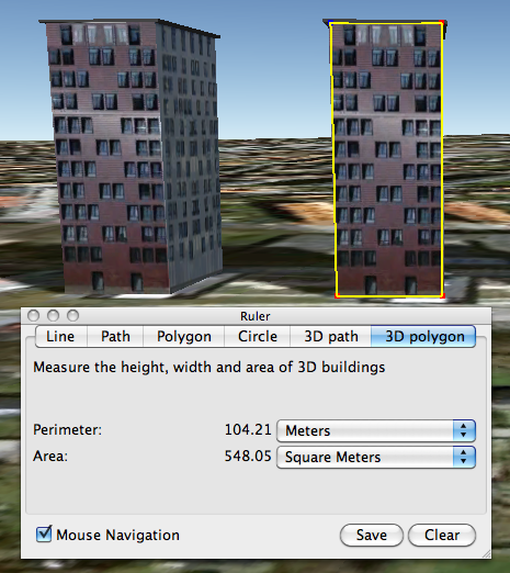
To measure buildings and distances between buildings, just turn on the 3D Buildings layer and click the Ruler Tool icon in the toolbar. If you’re running Google Earth Pro, you’ll notice two new tabs for measuring in 3D: 3D Path and 3D Polygon.

Here are a few examples of what the new Pro 3D Measurement Tools have to offer.

Measure the height or width of a 3D building:


Measure the area of the face of a 3D building:


Measure the distance between a building and a point on the ground or another building:


If you’re new to Google Earth Pro, try it for free for 7 days or buy Google Earth Pro today and discover how 3D Measurements can benefit your business. Onward and upward!

Posted by Cristelle Blackford, Google Earth Pro Team

Update 2:35PM: The first image in this post to demonstrate building height measurement has been updated.

Monday, November 15, 2010

Discover Yours: Local recommendations powered by you and your friends


There’s something so exciting about discovering new places. Nothing beats finding a great new place I’ve never been—whether it’s a new bakery with a special dessert, a hole-in-the-wall Mediterranean place I didn’t notice before or a local art gallery where I can let my imagination roam free.

The challenge with finding those great places is that each of us has different tastes. I want to find places I like and I want to find them quickly. So when I’m overwhelmed with possibilities, I turn to sources I can trust. For example, if I’m in a new city, I might chat with the concierge at my hotel and explain to him the kinds of places I like so he can give me personalized recommendations, or I’ll ask my friends for local recommendations because I value their opinions and we have similar tastes. But finding trusted advice is hard; wouldn’t it be great if there was a way for me to get these recommendations all the time, everywhere I go?

We are trying to do exactly that, and today we’re excited to share the first step: an early release of Hotpot - a local recommendation engine powered by you and your friends. With Hotpot, we’re making local search results for places on Google more personal, relevant and trustworthy. There are three main ingredients in the Hotpot recipe:
  • Google Places - These are the 50 million places around the world for which we have rich details.
  • The places you like - When you rate places you like, we’ll tell you about other related places you’ll love. I love my favorite neighborhood restaurant in Noe Valley, Firefly, so when I rate it 5 stars, Hotpot will try to recommend other places for me in the city with simple, homey food such as Home restaurant.
  • The places your friends like - Share your ratings with your friends and see the places they’ve recommended. I’m planning a trip to Barcelona for the holidays and my friend Bernardo is a local. With Hotpot, I can see his recommendations when planning my trip on Google Maps, or when I’m in Spain using Google Maps or Places for Android.

Combining these three ingredients makes the hard task of choosing where to go easy; all you need is to rate places and add your friends. To do that we created the Hotpot rating app: quickly rate all the places you’ve been to and choose exactly which friends you want to invite to Hotpot. Then, when you’re visiting places, you can continue rating on the go from Mobile maps on Android.

Rate from the Hotpot rating app


Rate from Mobile maps on Android

Your recommendations are with you whenever you need them. In search results, you can see recommended places by using the new Place Search and clicking on the “Places” filter. You can also see recommendations when searching on Google Maps, Google Maps for Android or when checking the Place pages for a specific business.

Recommendations on Place Search


Recommendations on a Place page


Recommendations on Google Maps for Android

You can set a Places nickname (here’s how) when you start using Hotpot, so you control how you post your ratings. That way, only your friends will be able to see your real name.

Happy hotpotting!

Posted by Lior Ron, Product Manager

Friday, November 12, 2010

New panoramic photos in Google Earth


Viewing photos in Google Earth has long been a popular activity for avid virtual globe-trotters. It's one of the best ways to "visit" places all over the world without paying for a plane ticket or getting jet lag. Today, the Google Earth photo viewing experience just got better with the addition of panoramic images.

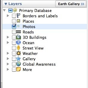
People using Google Earth will find a new "Photos" layer that includes not only the existing 2D photos from the Panoramio community, but also panoramic photos from around the world contributed by users of 360cities.net. These high-resolution panoramic photos are marked in Google Earth as red square icons. When you click on one of these icons, an info bubble containing an image appears, and clicking on the image again will take you into our photo viewing mode. You can then look around in 360-degree views and experience the place as if you’re standing right at the center of it.

new "Photos" layer on Google Earth


info bubble on Google Earth


These panoramic photos are shot by average people just like you and me. To contribute your panoramic photos, visit 360cities.net. We invite all users to become part of the community and mark your photo journey in Google Earth.

Check out some of the beautiful images now available right in Google Earth.

Golden Gate Bridge on Google Earth and on 360cities.net


Gapang Beach, Pulau Weh, Indonesia on Google Earth and on 360cities.net


Lion's Head, South Africa on Google Earth and on 360cities.net


Diving New Caledonia Amedee Island on Google Earth and on 360cities.net


Umag Asanas, Istria at sunset on Google Earth and on 360cities.net


Panthéon and Foucault pendulum, Paris on Google Earth and on 360cities.net


Posted by Wei Luo, Senior Geo Data Strategist

Monday, October 25, 2010

Advertise your local business with Google Boost


As a local business owner in today’s day and age, you know that it’s important to have an online presence because that’s where your customers are. In fact, research shows that 97% of people conduct research online before buying locally. Hopefully you’ve gone to Google Places to claim your free business listing that appears on Google and Google Maps. That enables you to share accurate information about your business such as your hours of operation, photos and videos - and now you can do even more.

Today, we’re announcing the availability of a new online advertising solution to help local businesses connect with potential customers in their area. Boost enables business owners to easily create online search ads from directly within their Google Places account. No ongoing management is needed after the initial set up, and this beta is currently available to select local businesses in San Francisco, Houston and Chicago.

Boost ads are eligible to appear in the “Sponsored Links” section of Google.com and Google Maps search result pages. For example, if you’re a restaurant owner in San Francisco who has signed up for Boost, your ad may show up when someone does a related search like the one below, indicating a cuisine and location that matches yours. Beyond the basics like your company name, address, phone number and website, your ad may also include the number of reviews you’ve received, an average star rating and a link to your Place page to help potential customers find additional useful information about your business. When a map appears alongside the results, a blue pin will help folks quickly find your location on the map. Businesses using Google Tags will also see their yellow tag appear in the ad.


To create your ad, all that is required is a short business description, a web or Place page, your business categories and a monthly budget. From there, our system automatically sets up your ad campaign - figuring out the relevant keywords that will trigger your ad to appear on Google and Google Maps, and how to get the most out of the budget you allotted. You’ll only pay when a potential customer actually clicks on your ad, and you can also view basic ad performance data from your Google Places dashboard.

Here is an example of the simple sign up page within Google Places, which takes just a few minutes to complete. To make the process even easier, the “description” and “categories” fields may be pre-populated with suggestions based on the information you provided on the Place page for your business.


We hope Boost provides busy local business owners with a quick and easy way to share information about themselves with the people who look for them online. Placement in the “Sponsored Links” section of the page will, as always, depend on factors such as your ad’s relevance and quality. Boost does not affect the ranking of the free, organic business listings in any way.

As we do with all beta features, we’ll carefully review the data and effectiveness of this trial and may make changes before making decisions about any future expansion. In the meantime, business owners can sign in or claim their listing in Google Places, and select businesses in San Francisco, Houston and Chicago will see an invitation to try Boost in the account dashboard. Interested businesses outside these areas can sign up to receive notification when Boost comes to their area by filling out this form.

Posted by Kiley McEvoy, Product Manager