Showing posts with label Africa. Show all posts

Wednesday, September 12, 2012

Elephants in Peril


Editor’s note: Today’s guest authors are Rob Heittman from Solertium, Inc., a technical development company and Iain Douglas-Hamilton, founder of Save the Elephants, based in Kenya. Save the Elephants was the recipient of a Google Earth Outreach Developer Grant, funded through the Google Inc. Charitable Giving Fund at the Tides Foundation. We’re hoping that mapping data patterns over time will shed much-needed light on the recent dramatic increase in poaching of elephants in Africa.

History is currently repeating itself in a quite unpleasant way.

Once again, as we did in the 1970s and 1980s, we are seeing previously tranquil elephants affected by huge surges in the illegal killing of elephants for ivory. We know, from past experience, that this ivory rush is fueled by a sudden increase in demand: new prosperity in Asian markets, where ordinary people can suddenly afford to buy ivory. After a relative respite since the 1989 ivory trade ban, I am sad to report that elephants are once again in peril.

Murembo, a bull elephant, from Tsavo National Park, Kenya
Photo Credit: Johan Marais

Save The Elephants operates a research camp in Samburu, Kenya; a very special place. The elephants there are protected by law, the ceaseless efforts of the Kenya Wildlife Service, local stakeholders, and amazing technology that helps secure their future. Within Samburu -- and other places in Africa -- we provide a tracking system which uses GPS radio collars to monitor the movements of elephants in near real time. Using Google Earth and our new, lightweight mobile apps, our team can be deeply knowledgeable about the Samburu elephants, and share data with the guardians to come to their aid if needed. Alerts tell us when unusual conditions occur. The most serious alert concerns immobility. This too often means another poaching incident, and another elephant's life lost to runaway demand for ivory.


Save the Elephants’ private Android and iOS apps allow for real-time elephant tracking, alerting rangers to elephants movements and poaching incidents.

We believe the ivory poaching we're seeing is a microcosm of what is going on across Africa. This past year, especially, there have been a series of massacres, for example, one in Cameroon in which almost an entire population was wiped out with automatic weapons.


Just 10 years ago, the areas in red, where illegal elephant killing is peaking, were showing healthy or stable elephant populations in green. Explore the changes over time in the timelapse feature.  Since 2008, major deterioration set in.

The other necessary part of the solution is to reduce the demand. Here, technology can also be a powerful ally. We are now using new Google technologies to bring the same level of awareness to anyone with a Web browser. With our most recent initiative, the Elephants in Peril site (http://www.elephantsinperil.org), we have turned to Fusion Tables and Google Maps Engine to do two important things. First, we are working to bring together public data sets, often buried in boring official reports, to reveal the complete story of elephant populations over time, map them out, and understand what trends can be seen. Second, we aim to share the real, unvarnished scientific data from whatever sources in a citable, and highly usable form.

As long as elephants continue to be threatened by surging ivory demand, we want Elephants in Peril to become a reliable source, whether a visitor wants to learn about the problem, write, tell about it, or take steps to help solve it. Google's simple data publishing and visualization tools make it possible for us to undertake this effort and reach a larger audience than would otherwise be possible.


elephantsinperil.org map shows main populations left in Africa with green being high density and red being low density.

We are in a race with the poachers; a race we have to win. Google Earth, Google Maps Engine, and Fusion Tables give us the advantage of speed. Already, we have used the system to share results with the media, and save weeks or months in achieving publicity. Later this year, we will publish original research that helps to tie our findings in Samburu to the challenges across the African continent, using the site to engage concerned individuals, NGOs and governments. In future, we look forward to translating the site into Chinese to improve its utility as a resource in Asia.

Google Earth Outreach and the Tides Foundation have made our mobile apps and Elephants in Peril possible. We welcome the assistance of any concerned Google developers or users. Please visit our website; even better, visit us in Africa if you can, and give us your ideas to help us win this race.

Posted by Dr. Iain Douglas-Hamilton, Founder of Save the Elephants, and Rob Heittman, CTO of Solertium, Inc.

Tuesday, August 28, 2012

Map Maker updates for Lesotho, Oman and Trinidad & Tobago


Since 2008, Google Map Maker has enabled anyone with an interest in cartography to update the maps of the areas they know, and improve their level of detail and accuracy. Whether adding new businesses, outlining building footprints, fixing road geometries or even tracing a favorite cycling route, citizen cartographers have joined together to create the most comprehensive maps of the world as seen on Google Maps and Google Earth.

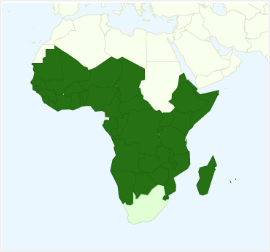
Just last week, top mappers across Africa attended the Map Maker Africa Regional Conference in Lagos, Nigeria where we proudly announced the release of Map Maker in Lesotho. This marks an important milestone, as the Map Maker tool now enables volunteer mappers to update and edit the entire continent of Africa. At the event, attendees shared learnings from past MapUps and ideas for future ones, told inspiring user stories, discussed product features with engineers, and closed out the conference with a sing-along led by users who wrote an original song about mapping!

A group photo of attendees at the Map Maker Africa Regional Conference in Lagos, Nigeria.

People’s enthusiasm for making maps more comprehensive and adding their local knowledge also continues to gain momentum in other parts of the world. Starting today, map data for Oman and Trinidad and Tobago, which has been added by people through Map Maker, will now appear as the base maps for these countries in Google Maps.

Below is a time-lapse video demonstrating how the map of Trinidad has evolved and changed over time—the result of many contributions people have made via Map Maker. Other time-lapse videos from around the world can be found here.


A big thank you to the passionate communities of volunteer mappers who made both the regional conference and Map Maker graduation possible. More mapping activity across the globe can be seen right as it happens via Map Maker Pulse. And remember, the maps of more than 200 countries and regions are now open for updates and edits, and awaiting your local expertise.

Wednesday, July 11, 2012

Google Maps for Africa gets better - walking directions launched!

(Cross Posted from Google Africa Blog)

In 2010, we announced the availability of driving directions on Google Maps in many African countries. This is a feature that allows users to get driving direction information from one location to another (e.g from Kotoka International Airport to Hotel Novotel in Victoria Borg, Accra in Ghana)

But of course not everyone drives or always needs to drive, so today we’re bringing walking directions for 44 African countries!


To get walking directions, start by doing one of the following:

  1. Click Get directions, enter a starting and ending location and click Get Directions.
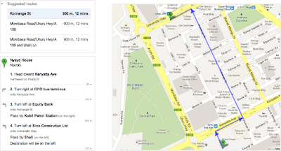
  2. In the search field, enter a from-to statement (example: from Nyayo House to Anniversary Towers) and click Search Maps.
  3. Click "Directions" in an info window that pops up for a business or location
  4. Right-click on the map to get directions to that location


Click on the “walking” icon at the top


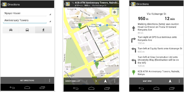
Walking directions are also available on Google Maps for Mobile.


Try out the walking directions today. As a reminder, walking directions are currently in beta, and we recommend that you use caution, as the routes may be missing sidewalks or pedestrian crossings. Walking directions are editable, so if anything is amiss, you can correct it with our community mapping tool Google Map Maker. Google Map Maker is a tool that allows you to add and update geographic information for millions of users to see in Google Maps and Google Earth.

We are always grateful to our active African online cartographers who have helped make our African maps what they are today.

We hope you enjoy using walking directions on Google Maps!