Showing posts with label SketchUp. Show all posts

Monday, April 2, 2012

Google Model Your Town 2012: Vote for the winner!


Cross-posted from the SketchUp Blog

The 212 teams that participated in this year’s Google Model Your Town Competition produced thousands of models, the vast majority of which were jaw-droppingly, heart-stoppingly, mind-bogglingly gorgeous. Narrowing down the field to six finalists was a gut wrenching affair, but it had to be done. In alphabetical order, the finalist teams for 2012 are:

Evansville, Indiana, United States | Evansville’s collection of models
Modeler: Randall Crane

Getaria, Gipuzkoa, Spain | Getaria’s collection of models
Modelers: Josetxo Perez Fernandez, Pedro Domecq Aguirre

Leominster, Herefordshire, United Kingdom | Leominster’s collection of models
Modeler: Tom Harvey

Lowell, Massachusetts, United States | Lowell’s collection of models
Modeler: Beryl Reid

ToruÅ„, Kujawsko-Pomorskie, Poland | ToruÅ„’s collection of models
Modelers: Arkadiusz Pawlowski, Górniak Grzegorz

Zielona Góra, Lubuskie, Poland | Zielona Góra’s collection of models
Modeler: Tomasz Szular

This video provides an aerial, musical tour of each of the six finalists’ models in situ. Make some popcorn and enjoy.


It’s voting time!

It’s up to you (and the rest of the world) to pick an overall winner. We’ve created separate one-minute video tours for each town, as well as KML files that you can download to see the models in Google Earth. Peruse the entries, then vote for your favorite. You have until May 1st, 2012 to cast your ballot.

Congrats and thanks to everyone who entered—this year’s models were truly amazing.


Posted by Allyson McDuffie, Google SketchUp Team

Wednesday, November 2, 2011

Recap: Google Geo User Summit in Barcelona


Settled between the Catalan Coastal range and Mediterranean sea, the city of Barcelona is home to an array of culinary treasures, iconic architecture, endless museums and beaches, and the impressive FC Barcelona football stadium. The city’s distinctive mix of tradition and innovation thus proved the ideal host to the Google Geo User Summit Barcelona. From October 12th-14th, Google Map Maker, Google SketchUp and Building Maker, and Panoramio welcomed some of our most passionate mappers, 3D modelers and Panoramio photographers across Europe and the Middle East to celebrate their invaluable contributions to an ever-growing Geo Community.


View of Barcelona from Museu Nacional D’art de Catalunya by Matthew Walters, Panoramio contributor

The summit was an exciting opportunity for many of our top contributors to share their geographic crowd-sourced efforts, work directly with Google engineers to brainstorm potential new product features, and set strategies for improving the overall Geo community. Attendees also had a chance to mind-meld with our product leaders during a day of unconference sessions, sharing thoughts, ideas, and stories about their experiences that will help us to improve our products.

Following a keynote address by Aidan Chopra, Google Geo Evangelist, attendees shared their inspiring projects and practices with a rapt audience. We learned from Levan Beruchashvili how the National Agency of Public Registry helped map the entire country of Georgia for its recent graduation to Google Maps. Arek Pawlowski described hosting multiple SketchUp workshops at his university, creating almost 450 models in an ongoing effort to put all of Toruń, Poland into 3D. As it is the user-generated content that fuels the Google Geo products, these and other contributor testimonials stood out as the highlight of the summit.

Attendees at the Google Geo User Summit Barcelona!

To learn more about the Google Geo User Summit Barcelona, visit the event website, where you can browse photographs of the conference and its beautiful setting along the Mediterranean coast. Extensive session notes and user presentations are also available. If you’re interested in attending future events, please see the Map Maker Events Calendar, 3D Events Calendar and Panoramio Events Calendar. This summit was one exciting part of an ongoing celebration of the passionate mappers, modelers, and photo contributors who are improving Google Maps and Google Earth for the world to share. A tremendous thanks to all those who attended and helped make the event a success!

Friday, October 28, 2011

Driving directions, biking directions … and now, carving directions!


We just couldn’t resist combining two of our favorite pastimes: pumpkin carving and geeking out about Maps. Behold: Pumpkin carving sheets to show off your Maps, Earth and SketchUp pride. Just click this link, hit print, and follow the how-to instructions.


Think you got skills? Let’s see ’em! We want to build a photo gallery of your finest work. Just send a photo of your Maps pumpkin our way on Google+ or Twitter using the hashtag #gmapspumpkin. Bonus points — and infinite bragging rights — for anyone who can pull off that Pegman.

Posted by Vanessa Schneider, Maps and Places community manager

Monday, August 22, 2011

Explore the ancient and modern with Rome in 3D

[Cross-posted from the Google SketchUp Blog]


Rome really is an eternal city. With a history spanning over 2500 years and regimes from the early kingdom, through the republic, the empire, and later as the heart of the Catholic faith in the Vatican city, each has made their mark on the current urban architectural landscape of Rome. Now, with the release of thousands of new 3D buildings for the city, you can explore the blending of the ages in layered construction of Rome from within Google Earth.


Let’s start our exploration in the ruins of the ancient Roman forum, home of the original Roman republic. From here we can easily travel to some of the subsequent Imperial buildings such as the Colosseum (AKA the Flavian Amphitheater) and Trajan’s Market and Column.


Looking towards the Colosseum through the Roman Forum


Next, we’ll head Northwest, towards the Pantheon and Piazza Navona. The Pantheon is a great example of the layered reuse of buildings in Rome; originally built in the Republican period, the Pantheon was retrofitted with the front portico in the Imperial period, and then later converted into a church. The shape of Piazza Navona also displays its historic foundation as the site was originally the Stadium of Domitian in the Imperial era.


Central Rome showing the Pantheon and Piazza Navona


Lastly, let’s head over to the Vatican City, where we can see great examples of the Renaissance and Baroque architecture of the city in Saint Peter’s Basilica and the colonnade by Bernini around St. Peter’s square.


St. Peter’s Basilica and Piazza in Vatican City


There is much more to explore in Italy’s modern capital, so have a look around this beautiful city! And don’t forget, a few years ago we also released ancient Rome in 3D which allows you to see Rome as it was in 320 AD.

To see Rome in Google Earth for yourself, use Google Maps with Earth view or turn on Google Earth’s “3D Buildings” layer and search for “Rome, Italy”. Alternatively, you can download this KML tour from the Google Earth Gallery to take a virtual tour of the 3D landmarks for yourself. As always, feel free to use Google Building Maker or Google SketchUp to make any improvements or additions to the city or to model your own town.


Happy touring!

Posted by Mason Thrall, Program Manager, Geo 3D

Friday, April 22, 2011

Celebrating top Geo contributors in the Asia Pacific region


In countries like India, Pakistan, the Philippines, and Kazakhstan, a community of passionate users is helping to bring geographic content online—in many cases for the first time. Using products like Google Map Maker, Google SketchUp & Building Maker, and Panoramio, these users are adding geographic information for millions of users to explore in Google Maps and Google Earth.

Recently some of the most active Map Maker mappers, 3D modelers and Panoramio photo contributors from around the region gathered in Singapore to attend the first ever Asia Pacific regional Geo Community Summit
.
Map Maker Software Engineer Robin Anil answers questions during a Q & A session.


The summit celebrated top mappers, modelers and photo contributors by asking individuals to tell their stories, brainstorm potential new product features directly with Google engineers during the unconference sessions, as well as make plans for events in the forthcoming year. We learned that India mapper CNR wakes up at 4:30am every morning to map. Pakistan mappers Faraz, Jabran and Omer worked together over the course of two years to map the roads of their country. They even turned Google Calendar into a way to track who was mapping what, and when! Thanks to the efforts of Map Maker contributors throughout the Asia Pacific region, more than a quarter of a billion people now have detailed online maps of the places they live.

Unconference session discussions

To learn more about this recent summit, you check out photos and videos or see detailed session notes and presentations on the event website page. If you’re interested in attending future events, please see the Map Maker Events Calendar, 3D Events Calendar, and Panoramio Events Calendar for upcoming activities. We look forward to celebrating more great achievements from our community of mappers, modelers, and photo contributors in the region.

Posted by Jessica Pfund, Program Manager, Google Map Maker

Thursday, January 13, 2011

Rebuilding L’Aquila in 3D with Google SketchUp

(Cross-posted from the Official Google Blog)

On April 6, 2009, a powerful earthquake struck l’Aquila, Italy. Three hundred and eight people died, and most of the buildings in the city center and surrounding areas were damaged or destroyed. About six months ago, we received an email from a British architect named Barnaby Gunning proposing an ambitious project: to use Google SketchUp to build a digital 3D model of the city, as it is now, in order to stimulate discussion about its reconstruction. He had already created a website—called Comefacciamo ("What can we do?")—to contact and organize volunteers.


Barnaby Gunning with the project T-shirt

Barnaby asked if Google would support a geo-modeling workshop in L’Aquila in an effort to create a digital model of the city. An engineer working on SketchUp and an Italian by birth, I was asked to travel to L’Aquila and give geo-modeling classes in Italian. I was excited! I could visit my motherland, teach people about the product I work on and help out with a project that could have a great impact on reviving the city. I ended up teaching six full-day classes over the course of two trips in October and November.


Teaching Google SketchUp skills to volunteers in L’Aquila

Teaching in Italian about a product on which I work almost exclusively in English proved to be more challenging than I thought. It took me awhile to get used to using the correct Italian name for the Push/Pull tool: Spingi-Tira. (It’s more fun to say, though.) The passionate volunteers who attended my classes more than made up for the language frustrations. Not only were they interested and attentive learners, but their desire to do something for their beloved city was contagious.


The church Santa Maria Paganica in real life (top) and modeled with SketchUp in Google Earth (below).

The modeling phase of the project is now in full swing. Several of the volunteers’ models have already been accepted into Google Earth—you can see them in your browser if you like. You can even take part in the project by helping to model the city from wherever you live. We’ve added L’Aquila to the list of places where you can use Google Building Maker to create geo-models, so no previous 3D modeling experience is necessary. If you’d like to dive in a little deeper, you can use SketchUp in connection with the many photos and other information on Barnaby’s website.

My few days in l’Aquila teaching SketchUp proved to be a fantastic experience. I met so many people who are enthusiastic about this project and willing to sacrifice their weekends to learn how to model, and to provide an exhaustive photographic record of the current situation. The time I spent with them was a wonderful remainder of the love they feel for their city—a love that I now share. I count myself lucky to be a participant in this important project.

Posted by Simone Nicolò, SketchUp Software Engineer

Thursday, December 16, 2010

The “City of Love,” now in 3D

[Cross-posted from the Google SketchUp Blog]

To foreigners, Paris is the “city of love.” To Parisians, it’s the “city of lights” (La Ville-Lumière). Today, Paris is the “city in 3D.”

Sunrise in Paris

Often considered one of the top destinations for world travelers, Paris is known for landmarks like the Notre Dame Cathedral and the Arc de Triomphe, world-famous museums like the Louvre and the Musée d'Orsay, and hundreds of little bistros with French pastries so good they make your heart pop (literally and figuratively). Now all of these sites – and the many, many others that make Paris special – are available to tour in 3D in Google Earth.


With Google Earth’s “3D Buildings” layer turned on (or by using the Google Earth plug-in for Google Maps) you can wander the streets of the Montmartre district made famous by artists like Picasso, Van Gogh and Dalí from your living room. You can also see the Sacré-CÅ“ur Basilica without having to climb the 237 steps to get there. Instead of waiting in line to see the view from the Eiffel tower, fly straight to the top in Google Earth and get a 360-degree view of Paris. Round out your tour by taking a peek at the Centre Pompidou, which turned the architectural world upside down (or perhaps inside out?) with its exposed skeleton and brightly colored building utilities.

Whether you’re an armchair tourist or planning your next vacation to France, take some time to tour the streets of the French capital and see the historic sites; after all, many of them were created by modelers just like you.

If you’d like to get involved in modeling your town (or any other location), we have several tools to get you started. With Google Building Maker, you can create and contribute a building in as little as 10 minutes. And if you’d like to refine your building, bring it into Google SketchUp for fine-tuning.

Happy touring!

Posted by Gopal Shah, Google SketchUp team

Tuesday, December 14, 2010

Building Maker: 109 cities and counting

[Cross-posted from the Google SketchUp Blog]

Today’s Google Building Maker imagery update is our last one for 2010 – you can now use our purpose-built geo-modeling tool in any of 109 cities around the world. We’ve just released imagery for:
  • Oklahoma City, Oklahoma
  • Oslo, Norway
  • The Hague, The Netherlands
San Antonio, Texas is one of the newest additions to Building Maker.

We also greatly expanded the coverage areas for San Diego, California and Portland, Oregon. And in case you missed the update two weeks ago, we also released imagery for:

  • San Antonio, Texas
  • Tucson, Arizona
  • Norfolk, Virginia
  • Salt Lake City, Utah
Norfolk, Virginia is itchin' to be modeled.

Still waiting for your city to be added to Building Maker? You can request it; in the meantime, try modeling in one of these new cities to help get them on the 3D map.

Friday, November 19, 2010

Earthquake motivates New Zealanders to model their town


Last week, local volunteers in Christchurch and Dunedin New Zealand invested a day of their time learning how to create 3D models using Google SketchUp. The workshops focused on learning how to geo-model, a process that involves creating 3D models of buildings from photographs for display in Google Earth.

The workshop was led by local architect and geo-technology expert Jason Mill of ZNO, who was inspired to organize the events following the recent earthquake in his hometown of Christchurch. As an architect, Jason recognized the value of having a publicly accessible digital model of the city, and has invested considerable time over several years modeling the central business district of Christchurch.

The value of these models took on new meaning when many of the heritage buildings in town disappeared, leaving the community to decide what should stand in their place.

Five hours away, the city of Dunedin was unaffected by the earthquake, but given its large number of heritage buildings, local residents there decided that it shouldn’t assume that they will be there forever. They suddenly felt a greater sense of urgency around creating a historical record of these buildings.


Historic preservation and city planning are two reasons that many people model their town, but there are numerous other benefits. Local business owners are keen to be represented on the 3D map, enabling virtual tourists another means to locate them on the Internet. Downtown organizations responsible for promoting their city are other beneficiaries. Exploring a destination virtually, whether for business or leisure, is becoming as common as reading a web site.

Google supports these workshops because it aligns with our mission to build a comprehensive atlas of the world online. This atlas is a dynamic, collaborative, open platform for visualizing, sharing, and searching geographic information—whether it’s in your local neighborhood or on the other side of the globe.

By providing free authoring tools like SketchUp and Building Maker, we’re making it easy to introduce 3D buildings to the map. Maps are no longer just 2D static images on paper, they’re living reflections of the local world around us. Everyone has the ability to help shape the map and contribute their local knowledge, experiences and points of view. Adding 3D buildings to the map is just one way to achieve that.

Local residents such as those in Christchurch and Dunedin are doing more than just putting their cities on the map, they’re contributing to an atlas of the world, and becoming the curators of the special places that their cities have to offer.

Posted by Bruce Polderman, Product Manager

Wednesday, November 17, 2010

New Japanese 3D cities available in Google Earth

[Cross-posted from the SketchUp Blog]

Today, we’re happy to announce that three more Japanese cities are viewable in 3D in Google Earth: Yokohama, Sendai and Saitama.

Sun rising over Yokohama.

You can now tour photo-realistic, 3D buildings in these cities without leaving your house—or climbing aboard a shinkansen.


If you’d like to extend your virtual stay in Japan, you can take a tour of Tokyo, Kobe, Osaka or Kyoto, which are also available in Google Earth’s 3D Buildings layer.

We want to thank the many users who modeled and contributed 3D buildings for these Japanese cities. If you’re interested in creating buildings for your town—or for any town—we have several easy-to-use tools to get you started.

With Google Building Maker, you can create and contribute a building in as little as 10 minutes. In Japan, Building Maker is available for the following cities: Fukuoka, Hiroshima, Kobe, Kyoto, Nagoya, Osaka, Saitama, Sapporo, Sendai, Tokyo and Yokohama. And if you’d like to refine your building bring it into Google SketchUp for fine-tuning.

Happy modeling!

Posted by James Therrien, Google Geo Group

Wednesday, November 10, 2010

Who's the newest Super Modeler? Vote!

(Cross-posted from the Official SketchUp Blog)

Today we’re announcing a new approach to bestowing “Super Modeler” status on our geo-modeling rock stars. More on that below—but first a little history.

A new form of 3D modeling began when @Last Software, the maker of SketchUp, was acquired by Google in 2006. Modeling 3D buildings for the purpose of viewing them in Google Earth went from being a quirky activity to a new art form. We refer to it as "geo-modeling.”

Being 3D enthusiasts ourselves, we were always on the lookout for good building models in the 3D Warehouse. When we discovered particularly impressive ones, we would add them to the featured modeler collection.


Church of the Savior on Spilled Blood by Arrigo Silva

Internally, we used the phrase “super modelers” to describe the people creating these amazing models, but it wasn’t until we started planning the first geo-modeling conference in August of last year that we began to publicly refer to modelers in this way. Following the event, a newsgroup was established, a collection created, and the user community representing some of the most skilled geo-modelers was officially born.

As the geo-modeling community expanded, so did the number of people creating remarkable models. We continued to add new modelers as we discovered them, and earlier this year we introduced badges in the 3D Warehouse—with one designated specifically for Super Modelers.

The coveted Super Modeler badge

With badges comes competition—more and more modelers began to ask how they could earn this honor. As time passed it became evident that we needed a clear set of criteria by which a modeler would be considered. The time had also come to establish greater transparency for how these decisions were being made, and who was making them.

So today we’re announcing a new process to become a Super Modeler—you decide!

It works like this: Each month the Super Modeler community will nominate ten geo-modelers who they believe are, well, super. Votes will be accepted for a three-week period. At the end of that period, the modeler who has received the most votes will become the newest Super Modeler.

In addition to being awarded a Super Modeler badge, the winner’s collection will be prominently featured on the Google 3D Warehouse until the next Super Modeler is selected. They'll also receive a one-of-a-kind “I’m a Google Supermodel(er)” t-shirt from the Google team.

It all starts now: Take a look at November's nominees, then cast your vote for the next Google Super Modeler!

Wednesday, October 20, 2010

Main Streets using Google SketchUp for Historic Preservation


Earlier in the year, we were approached by the National Trust for Historic Preservation to discuss how their member communities might leverage Google’s 3D modeling and visualization tools to support downtown revitalization programs. The concept for developing a digital model of a downtown area was conceptualized by the town of McMinnville, Tennessee, which was among the first small towns in the U.S. to organize a community modeling effort. With city budgets under pressure, the Trust was keen to explore how a community modeling approach could be expanded by downtowns across the nation.

The result was “Main Streets in 3D.” The concept was simple; a contest would be held among local Main Street programs where they would outline a vision for how their downtown would leverage a digital model. Five towns would be selected to receive a full day of training to develop 3D models of their downtown using SketchUp and Google Earth. The winning communities were announced in July.

Contest submissions varied from using the digital model for tourism promotion, to city planning, to creating an urban forestry plan – all ideal use-cases for having a publicly available 3D model. Despite the different goals, all five shared a common vision to use their Main Streets in 3D projects to attract entrepreneurs, jobs, investors, and visitors to their towns.


Igloo Studios, an authorized training center for SketchUp, coordinated with leaders in each community to schedule the training sessions. In early October, the last of the five communities gathered its volunteers to learn how to put their downtown on the digital map. Alex Oliver, CEO of Igloo Studios recently blogged about the experience.

With volunteers now trained, the project transitions to the development phase. Models such as these from Oregon City are beginning to appear in Google Earth.


All five communities will deliver a report on their progress at the National Main Streets conference in May 2011.

Posted by Bruce Polderman, Product Manager

Wednesday, September 1, 2010

Model the world with Google SketchUp 8

In the four years that the SketchUp team has been working at Google, we’ve seen an unprecedented collection of user-generated 3D building models spring up all around the world. It is exciting and gratifying to see what you’ve all been able to do with SketchUp, and we’re always looking for ways to make your work more effective.

For all of you who are in on the 3D modeling action, I’m proud to announce the release of Google SketchUp 8 today. We’ve added loads of new features specifically designed to make it easier for you to build Google Earth-ready models of the places that matter to you.

New features in SketchUp 8 include:
  • Major new features for modeling in geospatial context and for creating new 3D building models for Google Earth.
    • Model directly from Google’s massive collection of earth imagery, including aerial, oblique and Street View photography in addition to detailed geometric terrain and user generated 3D building models.
    • Import and improve models created with Google Building Maker
    • Participate in a community of geo-modelers collaborating on the shared construction of a detailed 3D model of the world.
  • new “Solid” tools in SketchUp Pro for common additive/subtractive modeling operations
    • “Outer Shell” to quickly simplify complex models imported from Building Maker
    • “Union, Subtract, Trim, Intersect and Split” to create complex additive and subtractive form from simple components.
  • additional features in LayOut for documenting models professionally
    • Custom line styles
    • a simple set of dimensioning and annotation tools
    • native document export to DWG/DXF 2010 format


SketchUp 8 is available today in English, French, Italian, Spanish and German with more languages to be release in the weeks to come. SketchUp Pro costs $495, upgrades from any earlier version are available for $95. And, of course, there is still a powerful version of SketchUp available for free.


Tuesday, August 31, 2010

Community Celebration in Peru

[Cross-posted from the SketchUp blog]

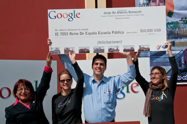
Recently, a team of Googlers traveled to Peru and celebrated the winner (and community) of the Google International Model Your Town Competition. Jorge De Albertis of Lima won through a process where people all over the world voted for one of five finalists. His ability to win so many votes was a testament to the power of a community coming together to support Jorge’s efforts. His contribution creating 3D models of many of the historical buildings in the Barranco District of Lima has garnered a lot of attention in his country, and worldwide.

There were four majors parts to the celebration:

1. As part of the winning prize, Google gave a donation to a public school of Jorge’s choice. Jorge talked to the students and staff at a ceremony in the school’s courtyard, and we presented a large check to IE 7053 Reino De Espana Public School. Googlers helped students with a hands-on paper 3D modeling project, where they constructed models of the buildings Jorge submitted for the competition. The school graciously hosted a celebration for Jorge and Google, which included a welcome by student marching bands, traditional Peruvian dances, ballerinas, theater acts, singing, and a poetry jam.


Click here to see more photos from the events.

2. Jorge and Google hosted a series of tech talks to over 80 design and architecture students and faculty at the University of Lima, explaining how others can get involved with modeling their communities. Demos were presented on Jorge’s project, SketchUp, Map Maker, and Building Maker. Watch a video of an interview of Jorge at the University of Lima.


3. The Latin America International Film Festival had a looping video of Jorge’s work running throughout the week.

4. Google held a celebration in Jorge’s honor at Picas, which was attended by designers, architects, educators, tourism officials, and the general Lima community. The fun-filled event had demo stations where people could learn more about Google Earth, Map Maker, Building Maker, and Google SketchUp. The band, Colectivo Circo played to a packed house. Jorge received a plaque and spoke to the community about his efforts. We are thrilled to have visited Jorge and to have met many people in the Lima community. Congratulations, Jorge!


Tuesday, August 24, 2010

Street View Imagery Available in Building Maker

[Cross-posted from the SketchUp blog]

If you’ve ever modeled a building in Google Building Maker, you may have found yourself wanting to use crisper, more detailed photos in addition to the aerial oblique imagery. Or, you may have had problems with poor textures caused by other buildings blocking the view of your building. In response to these issues we recently added the ability to add your own photos to Building Maker, but now you can also use imagery directly from Street View on Google Maps!

Start modeling your building using the aerial imagery. After you have constrained a block in at least two aerial images, you will be able to “Add Street View Images” from a drop down menu on the left-hand side. Capture a few images from Street View and continue modeling as normal. The following video illustrates an example of using this new feature:


We have also added 6 new cities to Building Maker (all, with the exception of Vienna, have Street View imagery!):

Edinburgh, United Kingdom
Florence, Italy
Vienna, Austria
Pittsburgh, PA, United States
Santa Cruz, CA, United States
Riverside, CA, United States

Try modeling with Street View imagery in Google Building Maker now!

Posted by Nicole Drobeck, Geo Community Advocate

Tuesday, July 27, 2010

Two Chilean cities added to Google Building Maker

[Cross-posted from the SketchUp blog]

For those of you who haven’t yet tried it, Google Building Maker is our simple 3D modeling tool that allows you to construct buildings by aligning various types of blocks to photos - all from your Internet browser. The completed models are automatically geo-located and then reviewed for inclusion in the 3D Buildings layer on Google Earth. When the tool was originally released last fall, users could create buildings in 50 cities. Since then, more cities have continually been added, and the growing tally is now at 94.

As part of our latest offering, we’re excited to announce that the cities of Santiago and Valparaiso in Chile are the first South American cities available in Google Building Maker.


Modeling in Santiago, Chile with Google Building Maker

We should note, however, that geo-modeling with Google SketchUp has been steadily increasing in that region for some time now. For example, avid user gananunez has been modeling in Valparaiso for a year and has more than 50 models in the 3D Buildings layer in Google Earth!


Valparaiso, Chile

Two other long-time users, GecKo StuDio. and Sergio, have been modeling Santiago since 2007 and each has more than 30 models in the 3D Buildings layer. Some users, like jgago93, are just getting started in the area.


Santiago, Chile

Now everyone can help model these two cities with Google Building Maker. Click here to start, and get your models on the 3D map!

Tuesday, July 20, 2010

Seville in 3D with Google Earth


[Cross-posted from the SketchUp blog]

We're pleased to announce that you can now explore the city of Seville in 3D with Google Earth. Take a virtual tour of the most symbolic buildings of the Spanish city, that range from the Roman Empire, through the Calatrava bridges to the best examples of contemporary architecture.


This is a unique opportunity to visit the Andalusian capital avoiding the summer heat. We encourage you to walk to the Torre del Oro, Plaza de España or La Real Maestranza - just using your computer mouse.

Tuesday, May 25, 2010

Stockholm is on the 3D map

[Cross-posted from the SketchUp blog]

Stockholm, which is said to be referred to as the “Venice of the North” may not receive a lot of sunlight throughout the year, but today it’s in the limelight as the newest city to be included in the 3D Buildings layer of Google Earth. Watch the video below to see Stockholm, Sweden in 3D:


Stockholm is a unique geographic location - filled with historic bridges, buildings, and parks. The rich architectural history make it a fulfilling destination for the virtual tourist.


The city's oldest section is "Gamla Stan"(The Old City). It's located on the original small islands of the city's earliest settlements and features cobbled streets and medieval alleyways.


And if time is short, make sure you fly over to The Royal Palace, the official residence ofHis Majesty The King. Explore Stockholm in 3D with Google Earth and now with Earth view in Google Maps.


Friday, May 14, 2010

Announcing the Google Model Your Town Competition winner

[Cross-posted with the SketchUp Blog]

On April 1st, we announced the five finalist towns for the Google Model Your Town Competition and asked the public to help pick the winning town. For the past month, participants reviewed the 3D models, explored the buildings in Google Earth and watched videos of the 3D towns.

Well, we’ve tallied the votes and we’d like to congratulate our 2010 winning town: Barranco - Lima, Peru!

Jorge De Albertis Bettocchi, a 38 year-old corporate business attorney, modeled the Barranco District of Lima. He entered the competition to generate pride among his fellow citizens and created his 3D models to serve as a tool for tourism, promotion, investment and preservation of Barranco’s historic architecture. Jorge also created a blog, Barranco 3D Project, that includes descriptions of his models, his modeling process, community involvement and press videos.


Jorge is also a musician who plays the keyboard, has a small recording studio, and has participated in the production of concerts in Peru. “I started creating SketchUp models in 2007 when I was asked to design a stage for a rock concert, and a concert-production partner recommended using SketchUp. Since then I have not stopped using it and it is the only 3D design program I have ever used.”

Jorge, you have impressed people all over the world with your SketchUp models. Congratulations to the Barranco community!

We’ll be awarding the local school district with US$10,000 and the SketchUp team is planning a visit to Barranco later this summer to recognize their efforts. Visit the Google Earth Gallery to download a 3D tour of Barranco, Peru and visit our winners page for more details.

Thanks to all those who voted to help us find the winning town. And thanks to all the modelers out there who submitted entries — we hope you'll continue to add 3D buildings to Google Earth!

Friday, April 30, 2010

Up close and personal

[Cross-posted from the SketchUp Blog]

We’re happy to announce that Nashville, Indianapolis, Charlotte, and Dallas are the newest additions to the family of Google Earth cities with high-quality 3D imagery. Exploring some of America’s most well-known cities from the comfort of your own computer just got even easier, and it also got more fun!

Whether exploring Nashville’s music venues along 2nd and Broadway, Indy’s Monument Circle in the heart of downtown, Charlotte’s diverse and numerous museums, or Dallas’s architecturally rich historic districts, the updated high quality 3D imagery will make you feel like you’re really there.

Give it a go in Google Earth or watch the video below for an up close tour!